Subject: Exploration & Surveys, Grand Canyon
Period: 1882 (published)
Publication:
Color: Printed Color
Size:
8 x 11.7 inches
20.3 x 29.7 cm
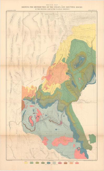
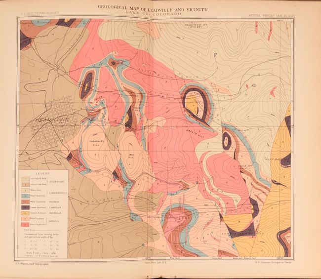
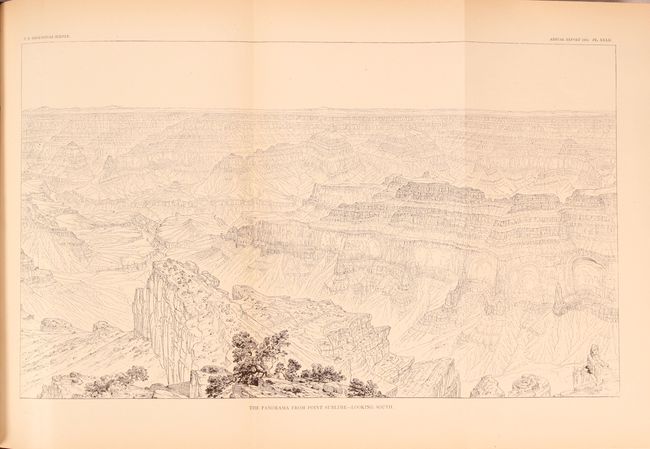
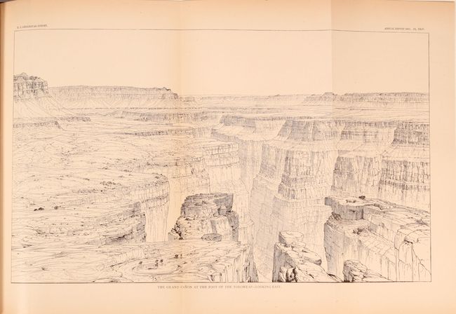
This important and complete volume contains reports on the Grand Canyon by Dutton; plus others including the history of Lake Bonneville; the geology of the Leadville, Comstock, and Eureka districts; the copper-bearing rocks of Lake Superior; and more. Also includes the administrative annual reports of F.V. Hayden, Clarence King, Dutton and others. Filled with colorful geological plates, plus the wide, folding b&w plates of the Grand Canyon such as: "Plateau Scenery - the Mesa Verde"; "Looking up the Toroweap Valley. Lava Cascades"; "The Panorama from Point Sublime - Looking East (also south and west)"; the "Vermillion Cliffs at Kanab"; "Kanab Canon" and more. Many of the wood engraved full page images are by Thomas Moran. Includes the colorful geological folding map at back in the original pocket entitled Sketch Map Showing the Distribution of the Strata and Eruptive Rocks in the Western Part of the Plateau Province (17.5 x 28.5").
This map is a very detailed and strongly colored geological map from the U.S. Geological Surveys. It details the region from Prescott (Ft. Whipple) and Camp Verde north through the Grand Canyon and Marble Canyon, today's Canyonlands National Park, Moab, and the southern portion of the Great Salt Lake. The map locates the Wasatch and Uintah Mountains, the Bad Land Cliffs (Book Cliffs), the San Juan River, etc. and has remarkable detail of the watershed and topography. This thematic map identifies ten geological units through color including: Tertiary, Cretaceous, Jurassic, Trias, Permian, Carboniferous, Silurian, Archaean, Trachyte Rhyolite & Andesite, and Basalt. Engraved by J.H. Renshawe.
Quarto, 588 pages, bound in original brown cloth with gilt lettering on spine. Includes 62 plates and maps, with many fold-outs and some in color, and 32 figures. The maps in this example were lithographed by Bien & Co. as opposed to the more common versions with lithography by T. Sinclair and Son.
References:
Condition: B+
The folding map is clean and bright with a bit of light toning along the folds. Text and other plates are also very clean with pleasant toning mainly along the sheet edges. Covers have light shelf wear and the edges are bumped.