Subject: Western Hemisphere - America
Period: 1659 (published)
Publication: Pierre d'Avity's Les Etats, Empires, Royaumes… du Monde
Color: Hand Color
Size:
21.7 x 16.2 inches
55.1 x 41.1 cm
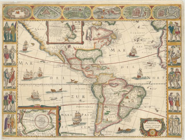
This is a very rare derivative of Hondius' important map of 1618. The engraver is unknown though it is closely copied from Picart's version of 1644, which was in turn derived from Jansson's map of 1623. North America retains the peninsular California and there is not a lot of detail along the eastern coast in the mid-Atlantic region. In the Southwest the famous seven cities of Cibola appear on the banks of a large spurious lake. In South America, the mythical Parime Lacus is shown to the south of Guiana and there are two engraved scenes, one detailing a cannibalistic feast and the other showing a mythical giant of Patagonia. Two stylized insets of the polar regions are enclosed in strapwork cartouches; the North Pole depicts Frobisher's theory of the Northwest Passage and the South Pole shows the long-held notion of the mythical southern continent.
The map is flanked on three sides with carte-a-figures borders describing the native Americans and its major cities. This map can easily be distinguished from Hondius' map because the figures at the sides were reversed when they were copied by the engraver. Unlike the similar Blaeu map, the cities at top include three North American towns: the Virginian Indian village of Pomeiooc, the French fort of Carolina, and S. Augustin in Florida. Blank verso.
References: Burden #333.
Condition: A
Issued folding, now flattened on paper with a "V" watermark. The left margin is narrow at bottom.