Subject: Arctic; Colonial Canada & Alaska; North Pacific
Period: 1775 (dated)
Publication: The American Atlas
Color: Hand Color
Size:
43.6 x 17.9 inches
110.7 x 45.5 cm
Thomas Jefferys was one of the most important English map publishers of the 18th century. His work included prints and maps of locations around the world, but his most notable maps are of North America and the West Indies. He began his career in the map trade in the early 1730s, working as an engraver for a variety of London publishers, and eventually setting up his own shop. In 1746, he was appointed Geographer to the Prince of Wales, and in 1760 he became Geographer to the King. These titles granted access to manuscripts and cartographic information held by the government. In the early 1760s he embarked on an ambitious project to produce a series of English county maps based on new surveys, but ran out of money and filed for bankruptcy in 1766. He then partnered with London publisher Robert Sayer, who reissued many of Jefferys plates and continued to issue new editions after Jefferys' death in 1771. Jefferys' American Atlas and the accompanying West-India Atlas, published post posthumously, are considered his most important cartographic works.
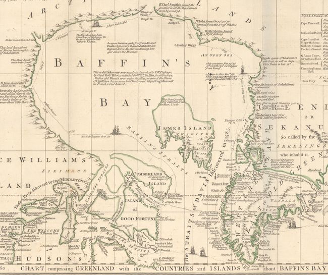
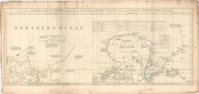
This is the top portion of Thomas Jefferys' large and important three-part map of the Americas, compiled in 1753 by Braddock Meade, one of the most intriguing figures in British cartographic history as well as an extremely gifted mapmaker. Working under the alias John Green after serving time for defrauding an Irish heiress, Meade compiled many of Jefferys' most important maps. The portion here focuses on the Arctic explorations into Hudson and Baffin Bay and on the Pacific Northwest coast. A complete map that stands on its own, with full borders, this was partly designed to expose the errors in Delisle and Buache’s map of the Pacific Northwest. This is the first map to label Bering Strait and is quite detailed, with a plethora of information on the explorers and their discoveries shown in various ways throughout the map. The tracks of Hudson and Baffin are shown and accented with sailing ships. Of particular interest are the tables at the top and left, which show the variations in latitude and longitude between Jefferys'' chart and those of Bellin, D'Anville, Moll, and Senex. There are indignant notes on the Pacific Northwest - "These parts, as yet wholly unknown are filled up, by Messrs Buache and Delisle with the pretended discoveries of Adm. de Fonte and his Captains in 1640." It also includes numerous notations concerning Russian explorations and presents a bulbous shaped Peninsula of the Tchuktschi whose Extent and Dimensions are unknown… Alaska, named here Alaschka is shown as a large island in the Anadirskiai Islands. It extends to include parts of Northern Asia and Iceland. This is an engrossing map, and a wonderful addition to any collection of the Pacific Northwest or Arctic. Two joined sheets, as issued.
Jefferys was the leading English cartographer of the 18th century, serving as both Geographer to the Prince of Wales, and later, Geographer to the King, positions that granted him access to the best surveys conducted in America. He published a series of maps of the American colonies that were among the most significant produced in the period, including the Fry/Jefferson map of Virginia, Braddock Meade’s map of New England, and William Scull’s map of Pennsylvania and the western frontier. His successors, Sayer and Bennett, gathered these separately-issued maps together and republished them as The American Atlas. According to Ristow, "[The atlas] was, very likely, consulted by American, English, and French civilian administrators and military officers during the Revolution."
References: Kershaw #450; Ristow pp. 31-32; Schwartz & Erhrenberg, p.158-59; Stevens & Tree #4-Sheet I & II (d).
Condition: B+
A nice impression on watermarked paper with light soiling and offsetting and some minor toning along the joint. There are several short edge tears in the blank margins.