Subject: Fort Royal, Guadeloupe
Period: 1762 (circa)
Publication:
Color: Hand Color
Size:
19.7 x 11.4 inches
50 x 29 cm
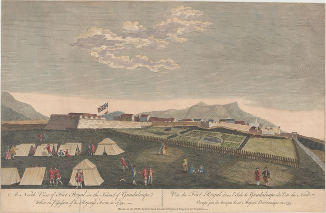
This rare view is based on a drawing made on the spot by Lieutenant Archibald Campbell of the Royal Engineers in 1759. Guadeloupe was a stronghold for the French, and became a target of the British during the Seven Years' War. In early 1759, a British fleet commanded by Major-General Peregrine Hopson and Commodore John Moore attacked and captured Fort Royal, which was located near Basse-Terre. This view shows a Union flag flying above the fort, with an encampment of soldiers outside of the fort and mountains in the background. Although the British succeeded in capturing Guadeloupe by May 1759, the island was surrendered to the French after the Treaty of Paris (1763). Although the imprint has been trimmed from this example, other examples of this engraving in museums show the following imprint: "London, Printed for John Bowles at No. 13 in Cornhill, Robert Sayer at No. 53 in Fleet Street, Thos. Jeffreys the corner of St. Martins Lane in the Strand, Carington Bowles at No. 69 in St. Paul's Church Yard, and Henry Parker at No. 82 in Cornhill."
References:
Condition: B+
A nice impression with minor soiling and archival repairs to a small hole at top right and to a tear in the bottom margin. Trimmed to the neatline at left, top, and right.