Subject: Black Hills, South Dakota
Period: 1875 (published)
Publication:
Color: Printed Color
Size:
6.3 x 9.3 inches
16 x 23.6 cm
This great set of maps are bound in the original "Appendix PP. Report of a Reconnaissance of the Black Hills of Dakota, Made in the Summer of 1874, by Captain William Ludlow, Corps of Engineers" dated April 28, 1875 from St. Paul, Minn. The 118 page report contains one plate illustrating fossils and the following three folding maps:
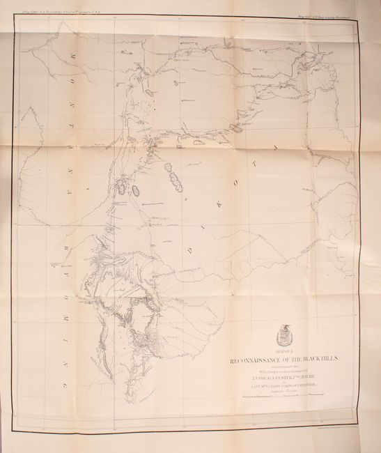
A. Map of a Reconnaissance of the Black Hills, July and August 1874, with Troops Under Command of Lt. Col. G.A. Custer, 7th Calvary, black & white (21 x 25.3"). This is Ludlow's principle map that shows the entirety of Custer's reconnaissance of 1874. The map extends from Old Ft. Pierre on the Missouri River to the Little Missouri Buttes and north to the Badlands and the Yellowstone River. In the summer of 1874, Custer took units of his 7th Cavalry and 2nd Infantry Companies on a now famous march from Ft. A. Lincoln into the Black Hills of the Dakotas. On this expedition, gold was discovered, which led to the Black Hills Gold Rush, then to Custer's massacre and eventually to the tragic end of the Sioux War at Wounded Knee. This map traces Custer's route through the region of the Black Hills with the date of each encampment. The map contains many interesting notations, such as "Where they killed the Rees," "Where the sickman was killed" plus many comments on water, grasslands, springs, etc. The topography is nicely developed and portions of Raynold's 1859 route is shown.
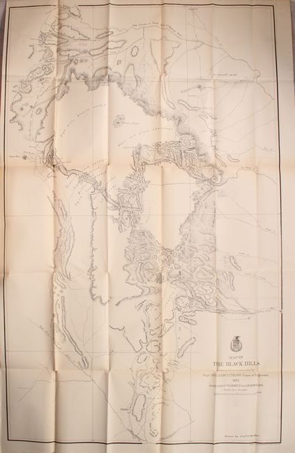
B. Map of the Black Hills from a Reconnaissance by Capt. William Ludlow Corps of Engineers, black & white (23.3 x 38"). A large map drawn by Sergeant C. Becker and one of three maps resulting from Custer's Expedition with additional geography from the maps of Warren and Raynolds. It covers the Black Hills between the Belle Fourche or North Fork of the Cheyenne River to the South Fork of the Cheyenne. Drawn on a scale of 3 miles=1 inch. Topography is nicely developed with portions of Warren's route of 1857 and that of Raynold's in 1859 shown. This expedition led to a discovery of gold and the subsequent Gold Rush into the Black Hills.
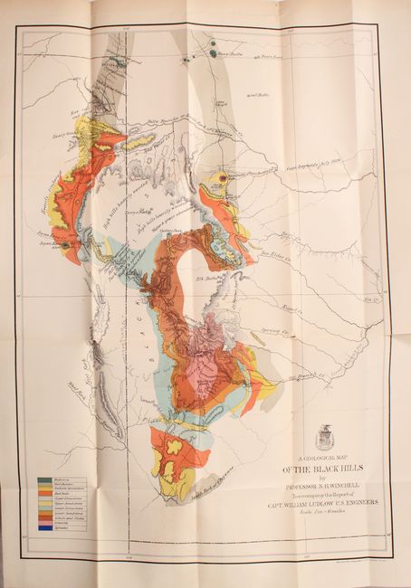
C. A Geological Map of the Black Hills, by Professor N. H. Winchell, To Accompany the Report of Capt. William Ludlow, U.S. Engineers, printed color (17.5 x 25"). In the summer of 1874, Custer was tasked with reconnoitering a route to Bear Butte and exploring the vicinity. Gold was discovered, leading to a major Gold Rush and an intrusion of white prospectors into the Black Hills, which are sacred to the Sioux and Cheyenne. This led to the Battle of Little Bighorn in 1876, and thus to the end for Custer and the 7th Cavalry. A legend in the lower left indicates eleven geological types through coloring and line and was one of three maps included in Ludlow's report. This map locates numerous creeks and gives detail of timber and topography.
Offered with Ludlow's report is the massive Annual Report of the Chief of Engineers to the Secretary of War totaling 1230 pages and includes reports by the likes of King, Michler, and Wheeler with many additional folding maps and plates. Hardbound in brown cloth with gilt title on spine.
References: Wheat (TMW) #1248-1251.
Condition: B+
The folding maps are very good with light toning, minor offsetting, and a few short fold separations. The geological map also has a closed binding tear confined to the left blank margin. Text is tight with light toning. The front hinge is starting and the covers show only light wear with bumped edges.