Subject: Maine
Period: 1901 (dated)
Publication:
Color: Black & White
Size:
55.5 x 32.3 inches
141 x 82 cm
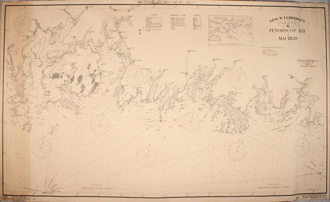
This large, linen backed sea chart is from Eldridge's series of New Coast Charts that covered the northeastern coast from New York to Maine. It covers the coast of Maine from Swans Island to Machiasport, including Mount Desert Island, Bar Harbor and Winter Harbor. There is excellent navigational detail throughout the chart. The legend locates 11 different type of buoys (many marked in red hand color on the chart), life saving stations, anchorages, rocks, and bottom types. Also shown are lighthouses (marked in yellow hand color), prevailing currents, and soundings. Dotted lines illustrate the shipping lanes including distances between ports. A small inset map shows a close-up of the area between Horse Ledge and Virgins Breasts. Below the map are advertisements for "Eldridge's Trim Gauge" and "The American Ship Windlass Co." On verso is the original paper label with title, with a price of $1.60, and a list of the other charts in the series. Large-scale nautical charts are generally rare on the market today due to the fact that they were used in a damp, rough environment and generally discarded as updated versions became available.
References:
Condition: B+
A nice impression with light overall toning, a strip of moderate toning and scattered foxing at far left, and some soiling at top. Lighthouses and buoys are marked in yellow and red hand color. Overall very good for a working nautical chart.