Subject: North America
Period: 1840 (dated)
Publication:
Color: Hand Color
Size:
24.9 x 35.5 inches
63.2 x 90.2 cm
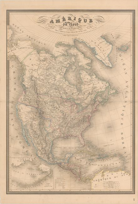
The Republic of Texas was a sovereign state in North America from 1836 to 1845. It was formed as a break-away republic from Mexico by the Texas Revolution. The nation claimed a large region that included all of the present state of Texas together with part of the former Mexican region of New Mexico (parts of present-day New Mexico, Oklahoma, Kansas, Colorado, and Wyoming). The eastern boundary with the United States was defined by the Adams-Onís Treaty between the United States and Spain, in 1819. Its southern and western-most boundary with Mexico was under dispute throughout the existence of the republic, with Texas claiming that the boundary was the Rio Grande, and Mexico claiming the Nueces River as the boundary.
This handsome elephant folio map of North America extends to include Central America and the West Indies. It is based largely on Brue's map of 1834 with some of the best western cartography of the period. Texas is shown as a Republic in a squashed configuration, with many of the early towns, forts and settlements depicted. Mexico is still in control of California and the present-day Southwest. In the Pacific Northwest, the United States-Canadian border is left undefined, likely a reflection of the Oregon boundary dispute. A large inset map details Alaska and the Aleutian Islands. Extensive information is noted in the various Indian districts. This is one of the most interesting large-scale maps of the pre-Fremont, post-Lewis & Clark era.
References: cf. Wheat (TMW) #415.
Condition: B+
Original outline color with light offsetting and minor toning. There is a short centerfold separation and an adjacent short tear confined to the left blank margin.