Subject: Northern Africa
Period: 1490 (circa)
Publication: Claudii Ptolemaei Alexandrini Philosophi Geographiam...
Color: Black & White
Size:
21.8 x 14.4 inches
55.4 x 36.6 cm
Claudius Ptolemy was a mathematician, astronomer and geographer who worked in Alexandria, then a part of the Roman Empire, in the 2nd century AD. One of the most learned and influential men of his time, his theories dominated both astronomy and geography for nearly 1500 years. His writings were kept alive by Arabic scholars during the Middle Ages and reemerged in Europe during the Renaissance. The birth of printing led to wide dissemination of his great works on astronomy and geography. There were a number of editions of his Geographia beginning in 1477. These early editions contained maps based on his original writings, known as Ptolemaic maps. As geographic knowledge increased with the explorations of Columbus, Magellan, Cabot and others, maps of the New World were added, and maps of the Old World were revised. Ptolemy's Geographia continued to be revised and published by some of the most important cartographers including Martin Waldseemuller, Sebastian Munster, Giacomo Gastaldi, Jodocus Hondius, and Gerard Mercator (whose last edition was published in 1730).
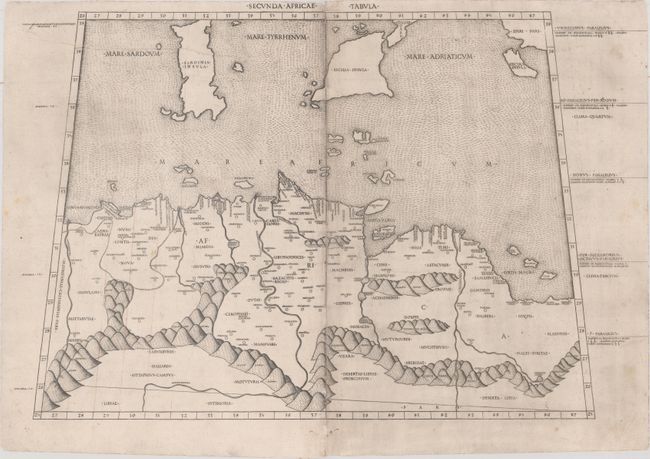
This is an extremely early, and rare engraving of the region of Tunisia with parts of Libya and Algeria, extending north to include Malta, Sicily, Sardinia and the island of Corfu (Cercyra). The map is beautifully engraved with stippled seas and exaggerated mountain ranges. This map first appeared in the 1478 edition of Ptolemy's Geographia, which was compiled by Jacobus Angelus and Domitius Calderinus, with the engraving supervised by Conrad Sweynheym and Arnold Buckinck. The same plates were used gain in the 1490, 1507 and 1508 editions. Nordenskiold explains that the maps from these editions were: "masterpieces of copper-plate printing, not surpassed for centuries, and they will still take the first place among the maps of all the numerous editions of Ptolemy's geography hitherto published." Printed from two plates and professionally joined.
References: Mickwitz & Miekkavaara #197-13; Nordenskiold (Facsimile Atlas) p. 14, #XIII.
Condition: B+
Watermarked paper with a printer's crease at top left, light soiling, and several small notations and lines of longitude written in old manuscript ink. There are a couple of tiny abrasions along the joint and a short separation along the joint at top.