Subject: Sri Lanka & the Maldives
Period: 1705 (published)
Publication: Algemeene Weereld-Beschryving…
Color: Hand Color
Size:
9.6 x 7.4 inches
24.4 x 18.8 cm
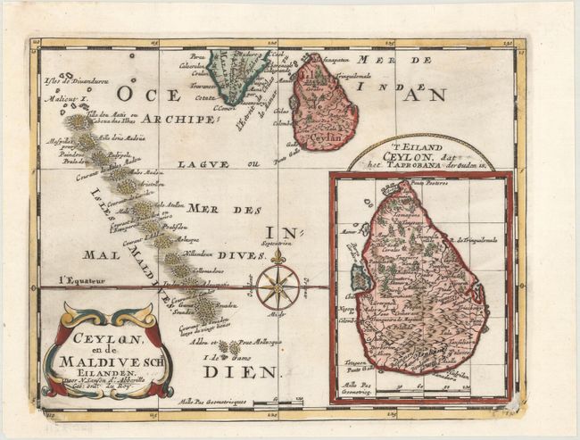
Exquisite map of Sri Lanka and the Maldives, with the southern tip of India shown at the top. Sri Lanka is shown in an inset named 'T Eiland Ceylon Isle, dat het Taprobana der Ouden is, Taprobana referring to the name given to the island on earlier maps. Nicely detailed and beautifully engraved with a decorative title cartouche and an attractive compass rose. The bottom corners of the plate are worn down. Published in Francois Halma's Dutch edition of A. Pherotee de la Croix's Nouvelle Methode Pour Apprendre facilement la Geographie Universelle.
Sanson's small maps from his L'Asie en Plusieurs Cartes..., first published in 1652 and engraved by A. Peyrounin, were copied several times by various map publishers. Johann David Zunners made copies of Sanson's maps for his German translation of Die Gantze Erd-Kugel in 1679. Johannes Ribbius and Simon de Vries published copies in 1682 and 1683, with new maps engraved by Antoine d'Winter. The plates were later sold to Francois Halma, who used them in 1699 and then again in 1705 with the titles re-engraved in Dutch. The titles on the d'Winter plates were re-engraved back into French, and then used by Nicholas Chemereau in 1715 and by Henri du Sauzet in 1738.
References:
Condition: A
A dark impression on a clean, bright sheet with the watermarks of a fleur-de-lis and a heart inscribed with the initials "VI." There are four small worm tracks in the compass rose that have been professionally infilled with a negligible loss of image.