Subject: Eastern United States
Period: 1810 (dated)
Publication: Travels on an Inland Voyage...
Color: Hand Color
Size:
18.4 x 16.3 inches
46.7 x 41.4 cm
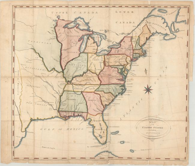
This is the largest of five maps included in Christian Schultz's Travels on an Inland Voyage Through the States of New-York, Pennsylvania, Virginia, Ohio, Kentucky and Tennessee.... The book describes Schultz's inland journey from New York state to New Orleans via the Ohio and Mississippi rivers, and is notable for giving an accurate and detailed account of the frontier. Howes describes the account as the "best description of this region at the period."
Cartographically, the map extends beyond the Mississippi River to past the 100th meridian. It depicts a large Mississippi Territory occupying present-day Alabama and Mississippi, with a huge Louisiana Territory of New Orleans to its west. To its south, no separate District of Louisiana is delineated. Florida is divided between East & West. The map locates numerous forts and mines along the Ohio and Mississippi rivers.
There are two interesting anomalies in the map: the names for North and South Carolina are reversed, and Indiana Territory is shown to the northwest of Illinois Territory. Other examples, apparently published later in the same year, have corrected the labeling issue in the Carolinas and renamed Indiana Territory to Northwest Territory.
References: Howes #S202; Sabin #78003.
Condition: B
Issued folding and now flattened and backed with old paper along the fold lines to reinforce and repair numerous fold separations. There is some minor image loss due to the separations primarily at fold intersections. Light soiling and foxing with a few other minor edge tears extending just past the neatline.