Subject: Colonial North America, North Pole
Period: 1702 (published)
Publication: Kurtbuendige Abbild-und Vorstellung der Gantzen Welt
Color: Hand Color
Size:
3.1 x 2.6 inches
7.9 x 6.6 cm
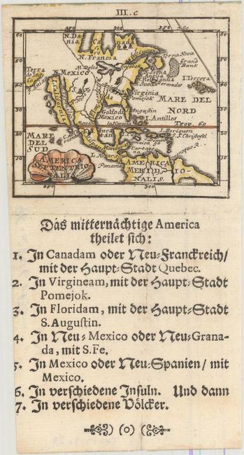
A. America Septentrionalis. This rare, tiny map features a large island of California of the Briggs type with a flat northern coast. Terra de Iesso is depicted across a narrow F. Anian to the west of California. Engraved by Bodenehr who drew heavily on Pierre Duval's similar map and includes several of the same anomalies; namely there is a double Hudson Bay, an inaccurate rendition of the Great Lakes, and Lake Champlain is located further southwest than it should be. The nomenclature along the east coast is outdated, including N. Hollandia and N Suecia. Santa Fe is located on the banks of a river (R. Nort) that flows into the Gulf of California. The title cartouche is engraved onto a shell-style cartouche. Engraved by Gabriel Bodenehr. German text is below the map. This is the second state with III.c above the top border.
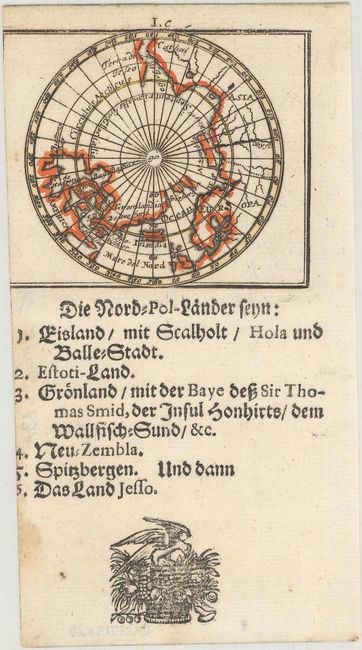
B. Die Nord-Pol-Lander.... This is another sheet from the same publication and depicts the North Pole. Like the former map, it is based upon Johann Christoph Hoffman's map of the region published in 1678. The double Hudson Bays are more exaggerated in this projection, and a small river on the Labrador coast is omitted. This is the second state with I.c above the top border. German text below the map.
References: Burden #687 & 688; McLaughlin #108; King (2nd ed.) pp.160-61.
Condition: B
Nice dark impressions on mostly clean sheets. The map of North America has a clean cut down the center of the sheet that has been nearly invisibly repaired on verso with archival material. The map of the North Pole is trimmed to inside the map image at left.