Subject: Southern United States & Mexico
Period: 1598 (published)
Publication: La Geografia de Claudio Tolomeo Allessadrino…
Color: Hand Color
Size:
9.7 x 7.1 inches
24.6 x 18 cm
Claudius Ptolemy was a mathematician, astronomer and geographer who worked in Alexandria, then a part of the Roman Empire, in the 2nd century AD. One of the most learned and influential men of his time, his theories dominated both astronomy and geography for nearly 1500 years. His writings were kept alive by Arabic scholars during the Middle Ages and reemerged in Europe during the Renaissance. The birth of printing led to wide dissemination of his great works on astronomy and geography. There were a number of editions of his Geographia beginning in 1477. These early editions contained maps based on his original writings, known as Ptolemaic maps. As geographic knowledge increased with the explorations of Columbus, Magellan, Cabot and others, maps of the New World were added, and maps of the Old World were revised. Ptolemy's Geographia continued to be revised and published by some of the most important cartographers including Martin Waldseemuller, Sebastian Munster, Giacomo Gastaldi, Jodocus Hondius, and Gerard Mercator (whose last edition was published in 1730).
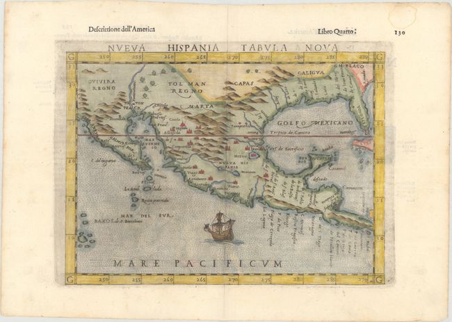
This is a foundation map in the cartography of the American Southwest, and a must for collectors of that region. It is an enlarged version of Gastaldi's map of 1548 with the only notable change being the peninsular Yucatan. The legendary seven cities of Ciuola are prominently depicted and Mexico City is shown floating in a large lake. The place names along the upper Gulf Coast reveal the explorations of Pineda, Cabeza de Vaca and Moscosso. The Mississippi makes its appearance as the Rio de Spiritu Santo and the R. Tontonteanc flows in the vicinity of the Colorado River. Considered the earliest relatively obtainable map of Mexico and the American Southwest. This is the third state according to Burden with the additions of Calmifor for California, Siera Nevad for the Sierra Nevadas and the addition of Mare Pacificum as well as a ship in the Pacific. Italian text on verso.
References: Burden #31; Martin & Martin, plt. 3; Wheat (TMW) #7; Mickwitz & Miekkavaara #227-63; Shirley (BL Atlases) T.PTOL-10f.
Condition: A
A clean and bright example with a dark impression and minor toning along the edges of the sheet. There is a faint damp stain at top right, well away from the image.