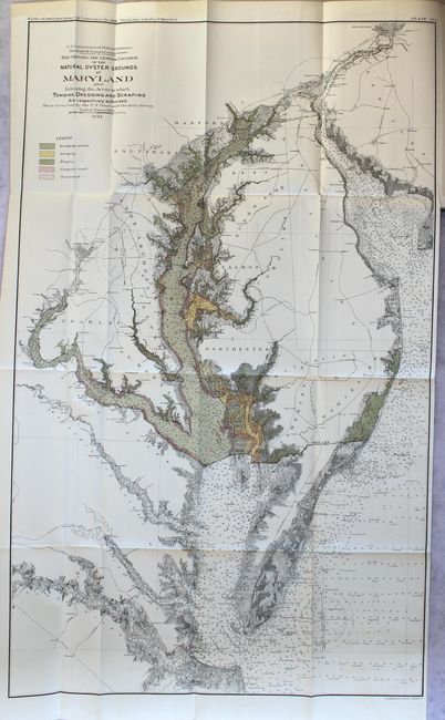
Subject: Maryland
Period: 1894 (published)
Publication:
Color: Printed Color
Size:
22 x 35.3 inches
55.9 x 89.7 cm
This colorful chart details oyster fishing beds throughout Chesapeake Bay and part of Chincoteague Bay in remarkably fine detail. The map locates Washington, D.C., Annapolis, Baltimore and Philadelphia in a street grid pattern. It locates areas where oyster gathering is authorized, and by which method, as shown by the color coded key at upper left to include Dredging, Scraping and Tonging. The legend also locates Compact and Scattered Reefs. By the 1870's, Maryland's oyster fields were becoming severely depleted, which led to oyster management efforts in the form of laws and regulations. The map is still bound into a bulletin of the U.S. Fish Commission containing 12 reports:
1. Bibliography of the Salmon of Alaska and Adjacent Regions, by Tarleton Bean
2. Life History of the Salmon, by Tarleton Bean
3. On the Viviparous Fishes of the Pacific Coast of North America, by Carl H. Eigenmann
4. Description of a New Sucker (Pantosteus Jordani) from the Upper Missouri Basin, by Barton W. Evermann
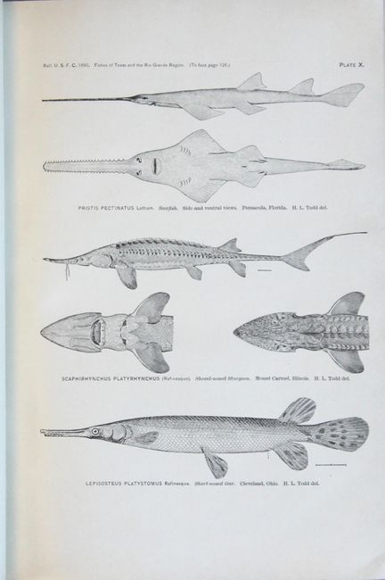
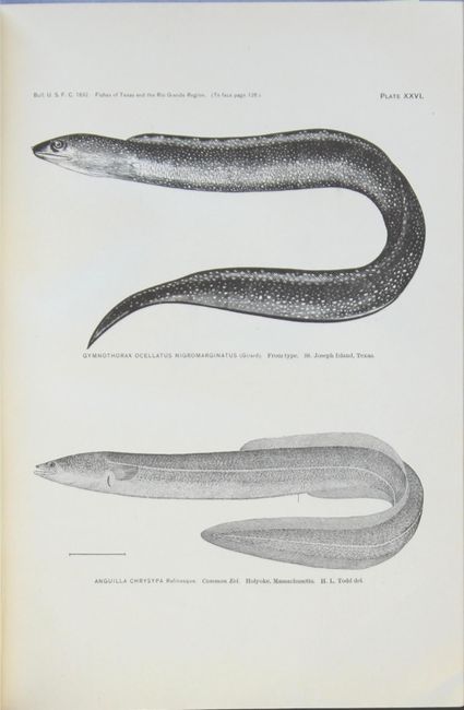
5. The Fishes of Texas and the Rio Grande Basin, Considered Chiefly with Reference to Their Geographical Distribution, by Barton W. Evermann and William C. Kendall
6. Report on the Salmon Fisheries of Alaska, by Marshall McDonald
7. List of Fishes Collected at Sea Isle City during the Summer of 1892, by H. P. Moore
8. Summary of Fishery Investigations Conducted in the North Pacific Ocean and Bering Sea from July 1, 1888, to July 1, 1892, by the U. S. Fish Commission Steamer Albatross, by Richard Rathbun
9. The Fyke Nets and Fyke-Net Fisheries of the United States, with Notes on the Fyke Nets of Other Countries, by Hugh M. Smith
10. Economic and Natural-History Notes on Fishes of the Northern Coast of New Jersey, by Hugh M. Smith
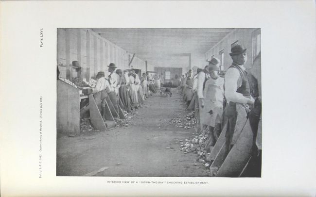
11. The Oyster Industry of Maryland, by Charles H. Stevenson
12. A Review of the Embiotocidae, by Albert B. Ulrey and C. H. Eigenmann
Of special interest is Stevenson's "The Oyster Industry of Maryland" (#11) and Evermann and Kendall's "The Fishes of Texas and the Rio Grande Basin" (#5). Stevenson explains that the purpose of his paper is "to discuss all branches of the oyster industry of Maryland, from the operations of the oystermen to the preparation of the marketable products, the investigation being chiefly from an industrial point of view." This study was conducted during a period known as the "Oyster Wars" between Virginia and Maryland. Regrettably, a similar study and map was never prepared by the Fish Commission for the Virginia portion of the Bay. For Texas and the Rio Grande, Evermann and Kendall describe the purpose of their paper to "include all the species, both salt and fresh water, which have ever been reported from that region, so far as we have been able to learn. Geographically, the paper is made to include not only the State of Texas, but all those portions of Colorado, New Mexico, and Mexico which belong in the hydrographic basin of the Rio Grande." The researchers identified a total of 230 species, of which 107 are illustrated on 50 plates, and of which 64 were known only to occur in Texas and Rio Grande waters. A further listing of 128 molluscs collected during the investigation are also given. The paper provides a valuable summary of historical and bibliographical references relating to fishes of the region dating from 1851 to 1892. The list of fishes provided by the authors for this region was the most comprehensive compilation published to date.
489 pages with 117 plates. Quarto, hardbound in dark brown cloth with gilt title on spine.
References:
Condition: B+
The map is vividly colored with a 1" binding tear at right that has been closed on verso with archival tape. There is also a bit of light toning confined to the top blank margin from where the map folded into the report. Text and plates are clean and bright with the exception of 2 pages of text that have two small edge tears repaired with old tape. The binding is somewhat loose and the covers are lightly worn with bumped edges. Ex-library bookplate on front pastedown.