Subject: Kentucky
Period: 1793 (dated)
Publication: Morse's The American Geography
Color: Black & White
Size:
17.9 x 19.5 inches
45.5 x 49.5 cm
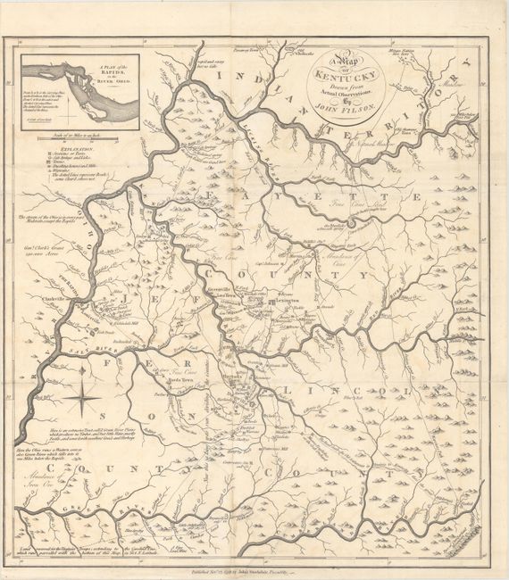
This rare Kentucky map was first produced by John Filson in 1784 and here republished in 1793, one year after Kentucky achieved statehood. The map extends from the Ohio River in the north to the Cumberland River in the south and shows three counties: Fayette, Jefferson and Lincoln. It is filled with notations including "a bloody battle fought here" and "the large Bones are found here." Also shown are settlements, prominent homes, mills, forts, "wigwams," salt licks, the river system, and topography. Numerous roads and paths are depicted, including a "Warriers Path," "Gen.l Clarks War Road," and a path connecting to the old settlements in Virginia "thro' the great Wilderness." Includes an inset at top "A Plan of the Rapids, in the River Ohio" which was not on the 1784 edition. John Filson (1753 - 1788) was the first Historian of Kentucky. Moving from Pennsylvania about 1782, he settled in Lexington where he divided his time between teaching and surveying land claims. He wrote The Discovery, Settlement and Present State of Kentucke in 1784, in which the first edition of this map was included. In 1788, while on a surveying expedition near the Great Miami River, he disappeared when the party was attacked by Shawnee Indians.
This edition was published November 23, 1793 by John Stockdale, and appeared in Stockdale's edition of Filson's The Discovery, Settlement and Present State of Kentucky (1793) and two different 1794 editions of Jedidiah Morse's The American Geography; Or, A View of the Present Situation of the United States of America... - one that included 3 maps and the other that included 25 maps. Although there were other reduced-sized editions of Filson's map that were published after the initial 1784 edition, the 1793 Stockdale edition is the only other full-sized edition of the map. It is also the only obtainable full-sized edition of Filson's map, as the 1784 editions are nearly all held in institutions.
An essential map for Kentucky collectors.
References: Howes #M840; Rumsey #0632.018; Sabin #50924; cf. Wheat & Brun #631.
Condition: B+
A sharp impression, issued folding with light soiling and offsetting, and now pressed and professionally backed with archival tissue to repair fold separations and tears. The repaired tears are all in the bottom third of the image, three of which extend about 1" to 1.5" from the folds at bottom left, and the other that extends 5" into the image at bottom right. There is a small sliver along the vertical fold at top and bottom that was likely cut by the bookbinder, and has been professionally replaced with period correct paper with a minor amount of the image seamlessly replaced in facsimile. Narrow left margin, as issued. The map presents itself very well.