Subject: Northwestern United States, Canada
Period: 1836 (dated)
Publication: A New Universal Atlas...
Color: Hand Color
Size:
12.3 x 10.6 inches
31.2 x 26.9 cm
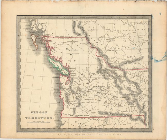
The United States and Great Britain established in 1818 joint claim over the Oregon Territory - the region north of Spanish controlled Upper California up to the southern boundary of Russia's Alaska Territory at North latitude 54°40'. By the late 1830's this arrangement was beginning to fall apart.
In the 1840's the expansionist Democrats, including their 1844 presidential candidate, James Polk, claimed the entire region for the United States. Their expansionist desires were expressed by Polk's famous campaign slogan, "Fifty-four Forty or Fight!" The slogan also became a rally cry for Americans desiring to settle the territory. Following Polk's election, the dispute was resolved by the 1846 Treaty of Oregon, which struck a compromise that fixed the U.S./Canadian boundary at 49º North.
This early map of Oregon Territory was copyrighted by the firm of Illman & Pilbrow in 1836 and published in Burr's atlas. A historical and interesting map, it draws on the explorations of Jedediah Smith, Lewis & Clark, the Hudson Bay Company and John Jacob Astor's Company for its remarkable degree of information and accuracy. The Oregon Territory extends all the way east to the Stony Mountains. The northern boundary with the British Possessions is set at 54°40' per the "Boundary of Russian Possessions settled by Convention in 1824." The southern boundary is at 42° per the "treaty with Spain 1819." East of the Stony Mountains, the northern boundary is today's Canadian border and noted as per the "treaty with Gt. Britain 1818." In the south, a remnant of the River of the West theory appears, as the Los Mongos River, that flows to the Pacific from the large L. Timpangos. Information and place names include Friendly Indians, Ft. Clapsop or Ft. George, Edmonton Factory, and much more. Burr was appointed to be topographer to the U.S. Post Office Department in 1832 and was unable to complete the maps for his atlas. Thomas Illman assumed that responsibility, publishing it using the New York firm of D.S. Stone. The imprint of Thomas Illman is below the neatline.
References: Wheat (TMW) #402; Rumsey #1941.
Condition: B+
A nice example with two small worm holes in the image and light soiling. There is some errant blue ink in the right blank margin and border.