Subject: North Pacific Ocean
Period: 1785-96 (circa)
Publication:
Color: Hand Color
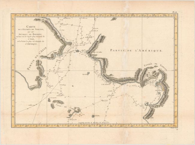
A. Carte de l'Entree de Norton, et du Detroit de Bhering ou l'on Voit le Cap le Plus Oriental de l'Asie, et la Pointe la Plus Occidentale de l'Amerique, by Cook/Benard, from Troisieme Voyage de Cook, ou Voyage a l'Ocean Pacifique…, circa 1785 (15.3 x 10.6"). French edition of this map from the expedition of Capt. James Cook. It covers the Bering Strait from south of Norton Sound to north of Cap du Prince de Galles and the corresponding coastline of Russia. Features include hachures representing coastal mountains, islands, place names, and soundings. St. Lawrence Island, Isles de Clerke is partially shown. Tracks of both the 1778 and 1779 exploration are delineated; Cook having done the former and Clerke the latter after Cook's death in Hawaii in Feb. 1779. Ref: Shirley (BL Atlases) G.COOK-4a #15. Condition: A crisp impression issued folding on watermarked paper with light damp stains along the folds, a short tear at a fold intersection at bottom, and faint offsetting. (B)
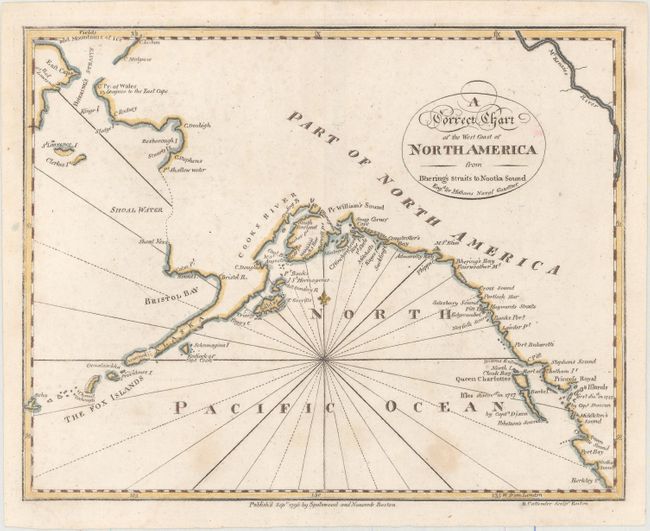
B. A Correct Chart of the West Coast of North America from Bhering's Straits to Nootka Sound, by Rev. John Malham, from Malham's Naval Gazetteer, dated 1796 (9.4 x 7.3"). This intriguing chart spans from Queen Charlotte Sound off the coast of British Columbia north to Bering Strait. References are made to the discoveries of Captains Cook, Dixon, and Duncan, but Vancouver's explorations, contemporaneous with the chart's publication, do not appear. The name Alaska appears on the Alaska Peninsula. Much of the coastline north of the peninsula is speculative and terminates in Fields, and Mountains of Ice above Bhering's Straits. The chart was engraved by B. Callender for Rev. John Malham (1747-1821), a writer and teacher of navigation, for the American edition of The Naval Gazetteer; or, Seaman's Complete Guide. Ref: Falk 1797-3; McCorkle (18th C. Geography Books) #253, Vol. I-2. Condition: There is light scattered foxing and a minor paper flaw along the centerfold. (B+)
References:
Condition:
See description above.