Subject: Central Africa
Period: 1601 (published)
Publication: Epitome Theatri Orteliani
Color: Hand Color
Size:
4.2 x 3 inches
10.7 x 7.6 cm
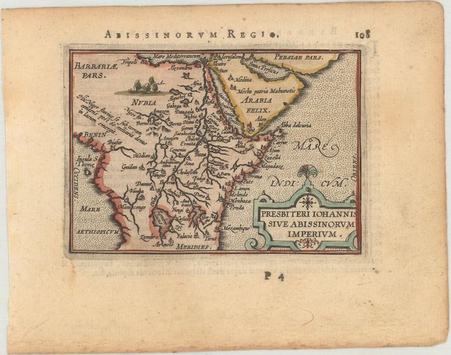
The mythical kingdom of Prester John is one of the most persistent legends of all time and often appears on early maps. This myth had its origins in rumors spread throughout Europe in about 1150 A.D. that there was a powerful Christian priest-king who had conquered the Muslims and founded the kingdom of Kara Khitai in Asia. This mysterious king became a symbol of hope in the Christian world, which at the time was beset by the Mongol hordes. A succession of Dominican and Franciscan missionaries and civil ambassadors were dispatched by popes and European monarchs to search for the kingdom. Many of these emissaries never returned, and those that did reported that the Christian kingdom in deepest Asia could not be found and was probably a myth. But the popular fancy was not easily dispelled, and so over time the location of the kingdom was merely transferred to Africa. Prester John's kingdom can be found on early maps in Scythia, India, Central Asia and Abyssinia.
Miniature map showing the domain of the legendary Christian king, Prester John. The map is dominated by the Nile River, which is shown emanating from twin lakes south of the equator. Latin text on verso.
This map was published in Filips Galle's series of Epitome, which first appeared in 1588. Galle was unimpressed with the maps in the Spieghel der Wereld, and therefore gradually replaced nearly all of them through the various editions of his Epitome. The new maps had simple double-lined borders and were widely copied by others. The plates were acquired by Jan Baptist Vrients circa 1600, who published three more editions in 1601 and 1602, retouching some of the plates and replacing a few more. By the time Vrients' 1601 edition was published, only 10 of the original maps remained.
References: King (2nd Ed.) pp. 64-65 & 88-89; Van der Krogt (Vol. III) #8720:332.
Condition: B+
A nice impression with light toning and marginal soiling.