Subject: Northern South America, Amazon River
Period: 1745 (circa)
Publication:
Color: Black & White
Size:
15 x 6.4 inches
38.1 x 16.3 cm
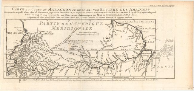
This interesting map is usually referred to as "the first scientific map of the Amazon" as it is based on astronomical observations conducted by Charles-Marie de La Condamine, a French explorer, geographer, and mathematician. After traveling to Ecuador in 1735 to test Isaac Newton's hypothesis that the Earth was not a perfect sphere, La Condamine was unable to travel back to France directly due to insufficient funds. Instead, he traveled eastward down the Amazon River from 1743-44, and performed the first scientific exploration of the great river, including notes on how the natives used curare for poison, and introduced rubber trees to Europe. This map depicts the Amazon River from its mouth in the Atlantic west to its tributaries in Colombia, Peru and Ecuador. This edition was published by the French Academy of Sciences.
References: Mercator's World (May/June 1999) pp. 18-25.
Condition: B+
Issued folding with a bit of minor staining near the center of the map image.