Subject: Martinique
Period: 1799 (dated)
Publication:
Color: Hand Color
Size:
23.3 x 17.8 inches
59.2 x 45.2 cm
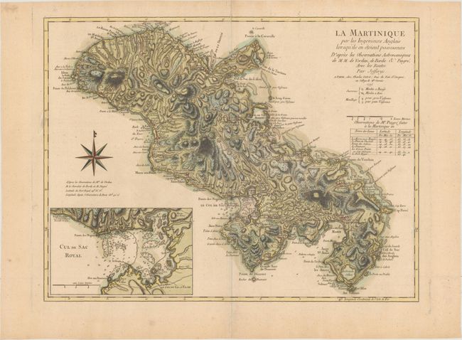
Thomas Jefferys was one of the most important English map publishers of the 18th century. His work included prints and maps of locations around the world, but his most notable maps are of North America and the West Indies. He began his career in the map trade in the early 1730s, working as an engraver for a variety of London publishers, and eventually setting up his own shop. In 1746, he was appointed Geographer to the Prince of Wales, and in 1760 he became Geographer to the King. These titles granted access to manuscripts and cartographic information held by the government. In the early 1760s he embarked on an ambitious project to produce a series of English county maps based on new surveys, but ran out of money and filed for bankruptcy in 1766. He then partnered with London publisher Robert Sayer, who reissued many of Jefferys plates and continued to issue new editions after Jefferys' death in 1771. Jefferys' American Atlas and the accompanying West-India Atlas, published post posthumously, are considered his most important cartographic works.
This French version of the 1775 Jeffreys map is skillfully executed especially with respect to the rugged topography that is shown by the use of hachures. The chart includes a large inset map of the Fort-Royal Bay. The map was drawn from surveys conducted by the British in 1762-63 when England briefly controlled the island. It provides an excellent view of the topography, rivers, sugar cane plantations, cattle mills, water mills, churches, hospitals, settlements, and roads in the interior, and forts, safe anchorages and navigational hazards along the coastline. The sugar trade made the island so valuable to the French government that at the Treaty of Paris (1763), which ended the Seven Years War, they gave up all of Canada in order to regain Martinique as well as the neighboring island of Guadeloupe. This edition, published by Charles Dien, has a table of longitudes and latitudes for various locations added below the title, based on the observations of astronomer Alexander Pingre.
References: cf. Sellers & Van Ee #2064.
Condition: A
A crisp impression with a small stain in the border at left.