Subject: Jamaica, Caribbean
Period: 1707 (published)
Publication: A Voyage to the Islands Madera, Barbados, Nieves. S. Christophers and Jamaica
Color: Hand Color
Size:
21.5 x 19.8 inches
54.6 x 50.3 cm
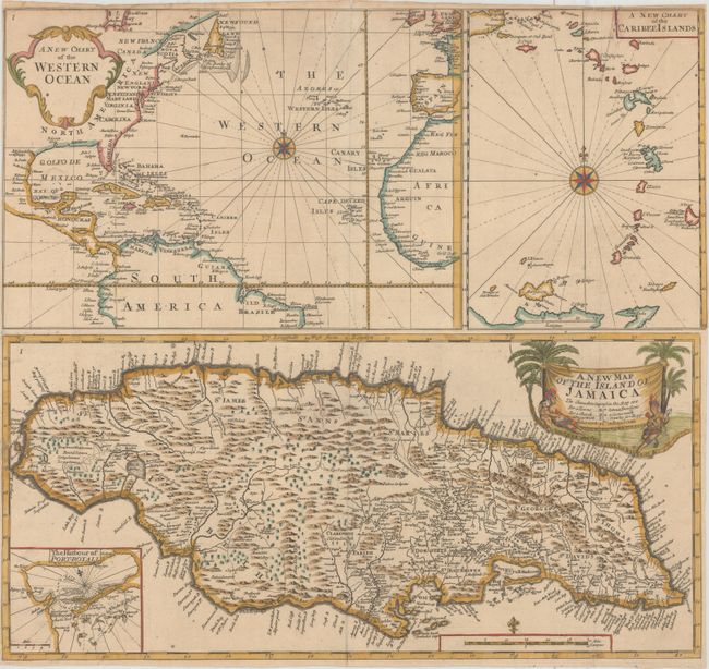
This map, by Sir Hans Sloane, appeared in his monumental work, A Voyage to the Islands Madera, Barbados, Nieves. S. Christophers and Jamaica, which was published in two volumes, with the first volume published in 1707 and the second in 1725. Sloane, an Irish-born physician and naturalist, was sent to Jamaica in 1687 to serve as the physician for the new Governor of Jamaica, the second Duke of Albemarle. During his 15 months in Jamaica, Sloane traveled extensively, recording information about the natural history, people, and productions of the island. He published his notes on the flora, fauna, climate, agriculture, trade links, people, and culture of the island in A Voyage to the Islands..., which included 284 plates and 1 large folding map.
The map actually includes three maps with separate borders, with a map of Jamaica occupying the bottom half of the sheet. The map of Jamaica gives good detail of the rivers, roads, settlements, and landowners on the island, particularly on the eastern end. The location of various types of production are also shown, including those for sugar, indigo, gotton, and cacao. An inset of Kingston Harbor (here Harbour of Port-Royall) provides navigational information. The cartouche for the Jamaica map features palm trees and a native American man, woman, and child. At the top of the sheet is another large map depicting the North Atlantic Ocean, with minimal detail except for place names along the coastlines. Adjacent to this map is a smaller map of the Lesser Antilles from the eastern part of Puerto Rico to the northern tip of South America.
This map is very rare; we were not able to find any records of this map being for sale in the last 30 years. Sloane's 2-volume work, with the map included, does appear on the market on occasion.
References: Kapp (MCC-42) #48; Sabin #82169.
Condition: B+
Issued folding, now flattened, with minor misfolds along the central fold and very light soiling. There are three small holes in the image that have been professionally repaired with old paper on verso, with a minor amount of image replaced in facsimile. Narrow margins, as issued.