Subject: Central America & Colombia
Period: 1733 (circa)
Publication:
Color: Hand Color
Size:
26.8 x 17 inches
68.1 x 43.2 cm
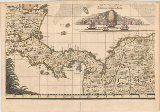
A beautifully rendered battle scene fills the Caribbean Sea on this finely engraved map. The battle scene depicts Wager's Action, a naval confrontation between a British squadron led by Sir Charles Wager and a Spanish treasure fleet on June 8, 1708 (although the engraving erroneously indicates the date as May 28, 1707). The British successfully captured one treasure ship and destroyed another, depicted here with men flying through a large explosion. This is sheet 18 of Popple's 20-sheet map of the British Empire in North America, focusing on Southern Honduras, Eastern Nicaragua, Costa Rica, Panama, Colombia. The map shows place names, topography, wind direction arrows, and shoals. The foliage at bottom left is part of the title cartouche.
Popple based his map on firsthand information gathered over several years at the Board of Trade and Plantations. The map was the first large-scale British map to provide an overall view of the eastern half of North America. As tensions grew between the colonial powers, the map became immensely influential throughout Europe and was copied by several cartographers. This is an early state printed on sturdy paper with no engraved page number in top margin.
References: Kapp (MCC-73) #46; Pritchard & Taliaferro, pp. 134-141.
Condition: A
A sturdy sheet with original outline color that has been refreshed, with additional color added to the decorative elements. There is minor toning along the edges of the sheet and an archivally repaired centerfold separation confined to the bottom blank margin.