Subject: Western United States
Period: 1879 (dated)
Publication:
Color: Printed Color
Size:
44.4 x 32.6 inches
112.8 x 82.8 cm
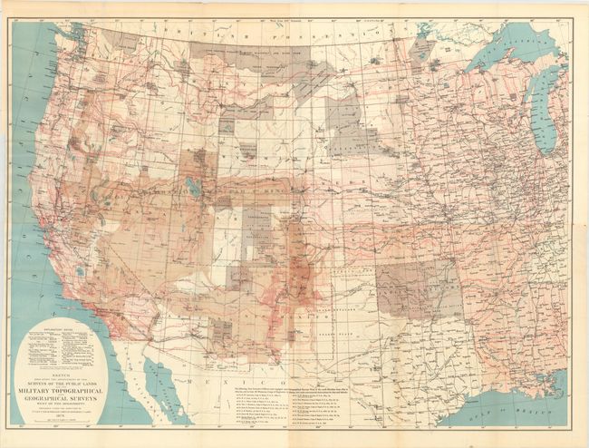
The 1870s was a period of intense effort, by such prominent people as Clarence King, Ferdinand Hayden, and John Wesley Powell, to advance the geographical knowledge of the West. These various surveys presented a threat to the Army's supremacy in the field of mapping and to the related appropriations from Congress. As a result of these pressures, the Army Corp of Engineers developed a plan to systematically survey the entire West to be called the U.S. Geographical Surveys West of the One Hundredth Meridian. The region was divided up into 95 rectangles, with atlas sheets to be prepared for each, comprising an area 2°45' of longitude and 1°40' of latitude on a scale of eight miles to the inch. Lieutenant George Wheeler was chosen to head this immense project. Surveys were conducted each summer from 1872 to 1878, after which Congress cut off appropriations for field work; thus the survey was not completed as originally envisioned. Wheeler published annual reports from 1873 to 1884, as well as the final Geographical Report published in 1889. The maps from this report are a valuable document of the record of Western exploration.
Large scale, beautifully lithographed in four colors with impressive detail throughout. The map locates more than 130 forts and camps (many flying tiny American flags), nearly 70 Indian reservations, the routes of dozens of early explorers, completed and projected railroads with their land grants, and dozens of Spanish land grants noted. Survey details plotted include base lines, meridians and townships. Wheeler's surveying efforts are shown as shaded regions. Map consists of four joined sheets.
References:
Condition: A
The map is clean and bright with archival reinforcements at fold intersections on verso. Issued folding.