Catalog Archive
Auction 162, Lot 166

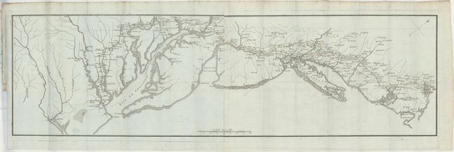
"[Untitled - Road from Boston to Yorktown]", Soules, Francois
Subject: New England & Mid-Atlantic United States, Revolutionary War

Period: 1787 (published)

Publication: Histoire des Troubles de l'Amerique Anglaise...

Color: Hand Color

Size:
35.9 x 10.3 inches
91.2 x 26.2 cm
Download High Resolution Image
(or just click on image to launch the Zoom viewer)

This uncommon and unusual Revolutionary War period map of the East Coast covers the region from Boston Harbor to the Chesapeake Bay. The map was one of three issued in Francois Soules' Histoire des Troubles de l'Amerique Anglaise. The main feature of the map is the road system from Boston to Yorktown, which is shown in yellow from Boston to Annapolis and in green from there to Yorktown. This road system was used by the combined forces of General Washington and Comte de Rochambeau as they moved south to attack the British at Yorktown. The map shows the sites of 54 camps along this route as well as 14 "marches" from Annapolis to Williamsburg. This map is believed to be based on a similar Rochambeau manuscript map held in the Library of Congress. Click here to view the map. Printed on two sheets, joined as issued.

References: Nebenzahl (Biblio) #185; Howes #S770.

Condition: B+

Issued folding on bluish, watermarked paper with original color, a few spots of soiling, faint offsetting, and light toning along the top edge of the sheet.

Estimate: $800 - $950

Sold for: $600

Closed on 4/26/2017

Archived