Subject: Florida
Period: 1900 (dated)
Publication:
Color: Printed Color
Size:
15.8 x 39.7 inches
40.1 x 100.8 cm
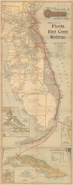
This map of Florida shows the Flagler railroad system from Jacksonville to Miami, with steamboat connections to Key West, Havanna, and Nassau. A table below the title shows the distances of the main line, branch lines, and steamship routes. County boundaries are depicted as well as cities, roads, canals, rivers and lakes. Includes 4 inset maps at bottom. Folds into tan paper covers.
References:
Condition: B+
A nice example with faint toning, occasional faint color offsetting, and one tiny split at a fold intersection. There is a bit of puckering of the paper near the title where the map was glued to the wrappers, which are near fine. Issued folding.