Subject: Central United States
Period: 1794 (dated)
Publication: The American Geography
Color: Black & White
Size:
8.9 x 7.3 inches
22.6 x 18.5 cm
By the time of the Revolutionary War, the practice of awarding bounty land as an inducement for enlisting in the military had been a long-standing practice in colonial North America. Besides imperial bounty land grants, both colonial and municipal governments routinely compensated participants in and victims of military conflicts with land. Land was a commodity in generous supply, and governments seized upon its availability for accomplishing their goals.
Following this tradition, the Revolutionary governments used bounty land grants in their struggle for independence from Great Britain. They generally offered free lands in exchange for military service, provided they were victorious in their struggle. Thus, bounty lands were an effective technique for enrolling support for the war and encouraging re-enlistments. Generally the bounty lands were located on the western frontier, which provided another benefit to the government. Populating the frontier with citizens skilled in defense offered the best prospect in enticing other settlers to join them, thus eventually increasing the tax rolls.
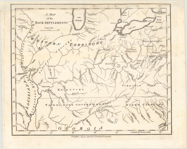
This is an unusual and uncommon map showing a portion of the early frontier, with a large Western Territory reaching from the Mississippi to Pennsylvania. Based on Thomas Hutchin's 1778 map, A New Map of the Western Parts of Virginia..., it is one of the earliest maps to name the Tennessee Government. It also depicts an area labeled Indiana in present-day West Virginia. This region was originally granted to a Philadelphia trading company by the Iroquois Confederacy in 1768. Then in 1776 it was sold to the Indiana Land Company, but was also claimed by the State of Virginia as a part of her original charter. The resulting battle between the private land company and Virginia resulted in the Eleventh Amendment to the U.S. Constitution and is one of the most interesting chapters in the history of the young United States. The map is also notable for its depiction of the Bounty Land Grants with the locations of the Illinois, New Jersey, Wabash and Ohio Companies and Army Lands. Early frontier forts are located including Ft. Massac on the Shawanee River, Post Vincent on the Fox River, Ft. Detroit west of Lake St. Clair, and Ft. Joseph southeast of Lake Michigan. An handful of Indian villages are named on tributaries of the Upper Ohio River. It was published in the rare English (Stockdale) edition of The American Geography by Jedidiah Morse, the first compendium of U.S. state and territory maps. A great example of one of the earliest maps of the region published after the American Revolution, predating the works of Scott, Carey and Reid. Stockdale's imprint appears at bottom: "Published, July 30, 1794, by I. Stockdale, Piccadilly."
References: Howes #M840; McCorkle (18th C. Geography Books) #302 [17]; Sabin #50924.
Condition: B+
A dark impression with chips at top that extend into the map border, which have been replaced with old paper with the border skillfully replaced in facsimile.