Subject: Mid-Atlantic United States
Period: 1794 (circa)
Publication: The American Geography
Color: Black & White
Size:
18.8 x 10.1 inches
47.8 x 25.7 cm
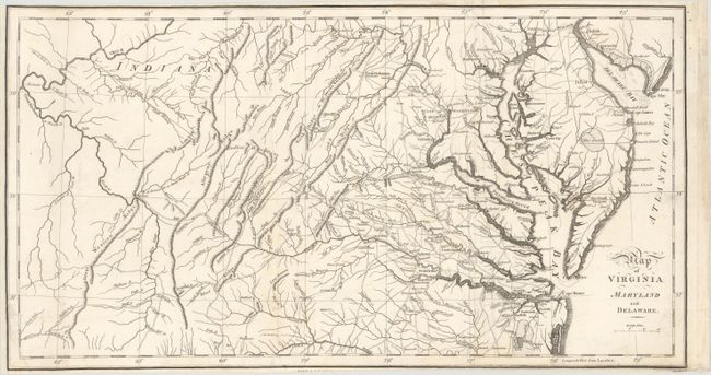
This regional map, focusing on the states of Virginia, Maryland and Delaware, was published in the London issue of Morse’s The American Geography. This rare book, containing 25 maps which focused upon the individual states and territories of the United States, is the earliest published compilation to do so. It predates Scott’s United States Gazetteer, Guthrie’s Geography and Mathew Carey’s American Atlas, all published in 1795. This map details the road development in the region at an early date and, while showing towns and geographic features, curiously omits most state boundaries and names. This is the second state of the map with the addition of the city of Washington, clearly an omission on the earlier state. Indiana, which is prominently labeled in what is now West Virginia near Ohio, probably refers to claims by the Indiana Land Company, which was litigating over ownership with Virginia at the time. Only three prior sales of this map have been noted in the last 30 years.
References: Howes #M840; McCorkle (18th C. Geography Books) #302 [16]; Sabin #50924.
Condition: B+
Issued folding, now flattened, with light soiling and minor extraneous creasing. Trimmed close to neatline at top and bottom, with loss of publisher's imprint at bottom and a chip at bottom that has been replaced with old paper. The neatline at left was partially cut off and then professionally reattached, with additional margin added.