Subject: Caledonia, Panama
Period: 1699 (circa)
Publication:
Color: Hand Color
Size:
22.3 x 17.4 inches
56.6 x 44.2 cm
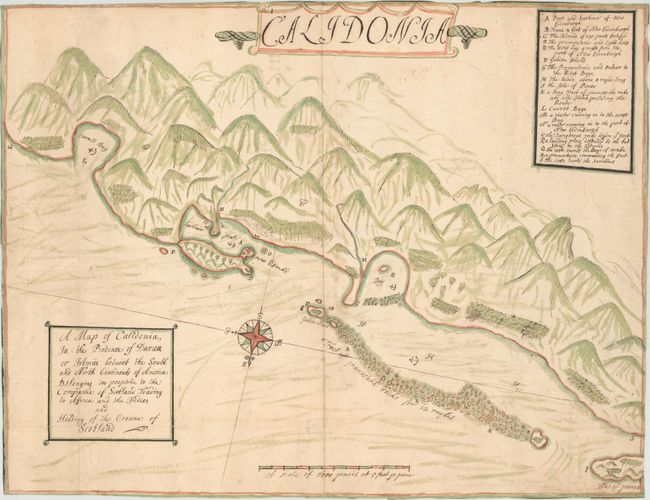
This fascinating manuscript map was apparently drawn around the time of the short-lived Scottish settlement of Caledonia on the north coast of Panama on the Isthmus of Darien. The isthmus was of strategic importance in the overland exchange of goods between the Atlantic and Pacific Oceans. Hoping to become a world trading nation, the Kingdom of Scotland created the Company of Scotland Trading to Africa and the Indies in 1695, a direct competitor to the English East India Company. The Company of Scotland, led by William Paterson, set sail in 1698 with five ships and 1,200 Scots to establish a colony on the Isthmus of Darien. They were instructed to build a settlement on the mainland near the Golden Island, which was near the entrance to the Gulf of Darien. The colonists built a fort and a main settlement named New Edinburgh on a peninsula on the mainland and attempted to farm and trade goods with the Natives. The colony failed within a year amid poor planning, devastating illness, and attacks by Spanish galleons. The failure of the Darien Scheme (as it became known) contributed greatly to the crippling of the entire Scottish economy that eventually led to the dissolution of the Scottish Parliament and the 1707 Act of Union with England.
This bird's-eye view depicts the fort and settlement of New Edinburgh just east of Golden Island. Several anchorages are shown in the harbor of New Edinburgh as well as neighboring bays. A "track of impassable rocks for 12 myles" is shown adjacent to Golden Island, with the Isle of Pines further west. A large compass rose orients north to the bottom of the sheet. The rugged and forested terrain along the coast is well depicted. A lettered key identifies many locations on the map. A secondary title cartouche at bottom left reads: "A Map of Calidonia, In the Province of Darien or Istmus betwixt the South and North Continents of America Belonging in propertie to the Companie of Scotland Trading to Africa and the Indies and Holding of the Crowne of Scotland."
This map was part of the collection of Captain Kit S. Kapp, who spent a number of years in Panama, yachting along the coast and conducting research on the Kuna Indians. Kapp was known as one of the foremost experts on maps of Panama, and authored the Map Collectors' Circle volume on The Early Maps of Panama up to 1865. He purchased this map in Scotland many years ago, although unfortunately the exact details have not survived. We have not been able to find any maps, manuscript or engraved, that are even remotely similar to this map.
References:
Condition: B+
The map appears to have been folded and inserted in an atlas or book. The watermark is a fleur-de-lis over a Strasbourg bend coat of arms with the cursive initials "A J" representing Abraham Janssen, and a countermark of "F S" in fancy lettering. There is light soiling and a few short separations and tears that have been repaired with old paper on verso. A few tiny cracks at top right along the thick black lines of the legend have been backed with archival material. Trimmed to the neatlines on all sides.


