Subject: Africa
Period: 1680 (dated)
Publication:
Color: Hand Color
Size:
34.7 x 22.3 inches
88.1 x 56.6 cm
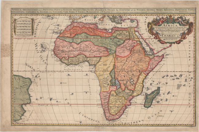
This very rare map was created by William Berry based on Alexis-Hubert Jaillot's 1674 map of the continent of Africa, which itself was based on Sanson's second map of Africa (1668). The map presents the standard Ptolemaic description of the source of the Nile. However, Jaillot introduced a new depiction of the rivers south of these Ptolemaic lakes. The Zambeze River appears above the Zambere and Rio de Spiritu Santo, all of which flow into the Indian Ocean. A large section of South America is shown and two St. Helena islands appear - a common error in maps from this period. The large distance scale cartouche has five scales (in contrast with Jaillot's map, which has 6 scales). The very large and decorative title cartouche, also copied from Jaillot, includes a tumult of figures, cornucopias, elephant, crocodile, lion and ostrich, although Berry changed the coat of arms to that of the Royal Arms. Berry did not issue standard atlases, but rather issued his maps in untitled collections. Even so, very few examples of his "atlases" have survived, and his maps are exceedingly rare. Two sheets joined, as issued.
References: Betz #124; Norwich #47; Shirley (BL Atlases) T.BERR-1a #35.
Condition: B+
Light soiling with paper watermarked "W" and a short repair in bottom right corner that has been professionally repaired. There is an old manuscript notation in left blank margin, and the margins have been professionally extended to accommodate framing.