Subject: Africa
Period: 1552 (circa)
Publication: Cosmographia
Color: Hand Color
Size:
13.6 x 10.1 inches
34.5 x 25.7 cm
Sebastian Munster (1489 - 1552) was one of the three most renowned cartographers of the sixteenth century, along with Mercator and Ortelius. Munster's Geographia and Cosmographia Universalis were two of the most widely read and influential books of the period. His editions of Ptolemy's Geographia, published between 1540 and 1552, were illustrated with 48 woodcut maps, the standard 27 Ptolemaic maps supplemented by 21 new maps. These new maps included a separate map of each of the known continents and marked the development of regional cartography in Central Europe. The antique geography was a prelude to Munster's major work, the Cosmographia, which was published in nearly 30 editions in six languages between 1544 and 1578 and then was revised and reissued by Sebastian Petri from 1588 to 1628. The Cosmographia was a geographical as well as historical and ethnographic description of the world. It contained the maps from the Geographia plus additional regional maps and city views with nearly 500 illustrations which made it one of the most popular pictorial encyclopedias of the sixteen century.
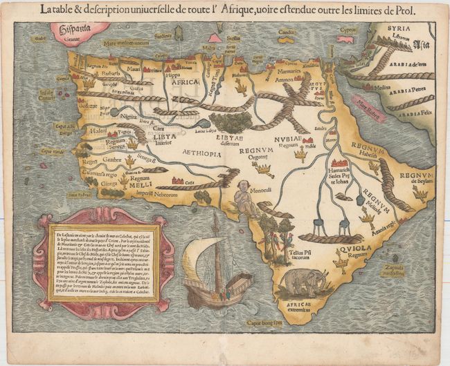
This is one of the first modern maps of the whole continent. The Ptolemaic geography, with large rivers and convoluted mountains, is augmented from Portuguese and Arabic sources. From the Portuguese comes Caput Bonespei (Cape of Good Hope) and a small group of islands off the eastern coast named Zaphala Aurifodina that were supposedly the region from which King Solomon imported gold and silver. The Arab kingdoms of Quiola and Melinde appear in eastern Africa and Hamarich, the capital of the mythical Christian king Prester John, is shown at the confluence of the twin sources of the Nile. The island of Madagascar is strangely absent, even though its presence was known from the time of Marco Polo. The map is illustrated with crowns and scepters indicating kingdoms, forests, parrots, an elephant, a Cyclops (Monoculi) and a large galleon under full sail. The strapwork cartouche contains a text description of the continent. French text on verso, published in the 1552 and 1555 editions of the Cosmographia.
References: Betz #3, variant 10; Norwich #2; Tooley (MCC-29) #10.
Condition: A
An attractive example with minor professional repairs along the centerfold at bottom, primarily confined to the blank margin, and marginal soiling.