Subject: Western United States
Period: 1859 (published)
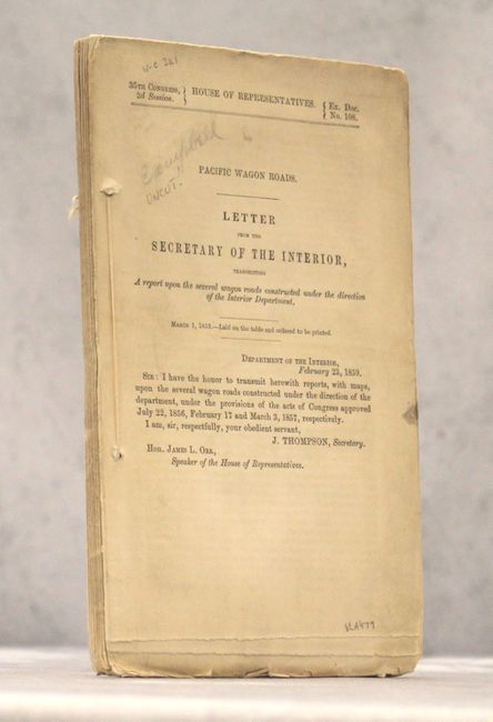
Publication: Sen. Doc #108, 35th Congress, 2nd Session
Color: Black & White
Size:
6 x 9.8 inches
15.2 x 24.9 cm
This 125-page report relates to the construction of the Pacific Wagon Road from Independence, Missouri to Honey Lake, California. Carl Wheat devotes a chapter to the project, concluding "The Department of the Interior was caught up in the currents that surrounded the oncoming Civil War, and little came of the imposing wagon road program that it had set in motion. [However] its efforts were of great effect on all parts of the West." Included with the report are the following six maps:
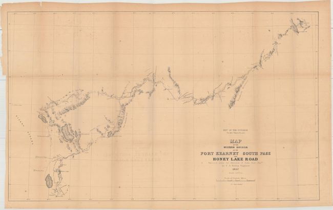
A. Map of the Western Division of the Fort Kearney South Pass and Honey Lake Road (35 x 21.3"). Extends from south central Idaho at today's City of Rock National Reserve and follows the Humboldt River to the vicinity of Carson City. Each day's camp is shown as the route travels through Humboldt Canyon, Fremont Canyon, Truckee Meadows and Carson Valley. Locates Carey's Mill south of the Carson Valley. Locates the lakes of Pyramid, Humboldt, Honey and Bigler an early named for Lake Tahoe.
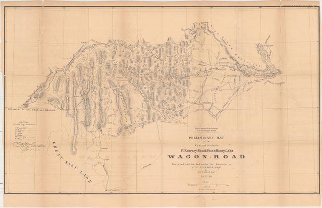
B. Preliminary Map of the Central Division Ft. Kearney South Pass & Honey Lake Wagon-Road Surveyed and Worked Under the Direction o F.W. Landers, Supt. By W.H. Wagner Engr. (34 x 20.5" ). Very detailed with topography shown via hachure. Centered roughly on Bear Lake, the map extends from City of the Rocks and American Falls in the West to Fort Aspen and Gilbert's Trading Post at the east. Salt Lake City is located at the extreme bottom. Locates numerous place names, mountain passes, etc. Names forts: Hall, Piney, Thompson and Aspen.
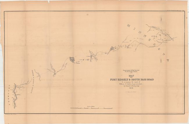
C. Map of the Fort Ridgely & South Pass Road to Accompany the Report of William H. Nobles, by Samuel A. Medary, Engr. (32 x 18.5"). This highly detailed map delineates the 255-mile long road between Fort Ridgely westward to the Missouri River around today's Chamberlain, South Dakota. The route heads west, initially following the Cotton Wood River. It passes by Lynd's Trading Post, Old Indian Fortifications, the Plateau du Coteau du Misouri, and crosses Red Wood Creek, Big Sioux River, Wolf Branch of Morse's Creek, Dacota or James River, and Wessington Springs. It locates the Lower Sioux Agency, New Ulm, Tuttles Winter Quarters with a nearby Indian Village, and Agency Mills. The completion of the road was hampered by prairie fires and by the Yankton Sioux demanding compensation. Drawn by John R. Key for Samuel A. Medary, Engr. to accompany the report of William H. Nobels, Superintendent. Lithographed by the Philadelphia firm of T.S. Wagner.
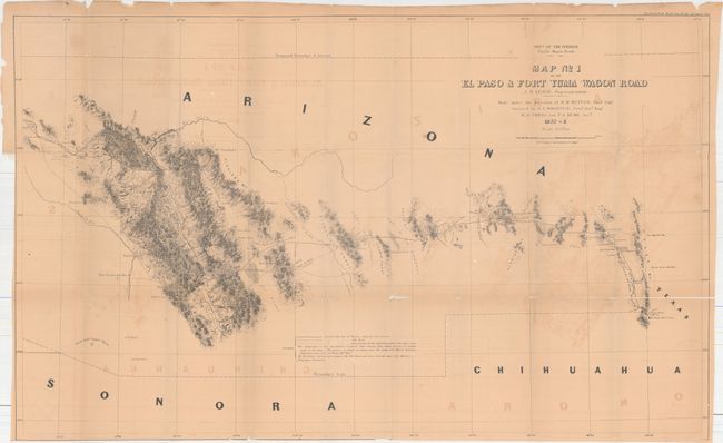
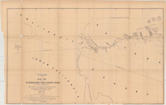
D & E. Map No. 1 of the El Paso & Fort Yuma Wagon Road, J.B Leach, Superintendent [together with] Map No. 2… (36.3 x 22.3"). Matching pair of maps issued as part of Campbell's "Wagon Roads… A Report Upon the Several Roads Constructed." Very detailed along the road with numerous notes. Shows line of the current Wagon Road, as well as the old road and routes of the exploring parties of Eng. Corps. Shows a very early boundary for the proposed and named territory of Arizona in the southern portion of New Mexico territory. This is the only U.S. Government published map we are aware of that shows the proposed boundary of Arizona in this configuration, all others being commercial. Locates and names springs, mail stations, forts, tanks, Indian villages, missions, and much topo info. The route from El Paso travels through Las Cruces, Cooke's Spring, El Piloneillo (near the current AZ/NM border), Parke's Railroad pass and north to the junction of the Salt, then northwest to Pima Villages (Phoenix). The route continues on map No. 2 from Maricopa Wells to the Foot of the Little Desert and on to the Colorado River and Fort Yuma. This is the end of the route but the mail and wagon road continues in skeleton form to San Diego and Los Angeles. No.1 measures 36.3 x 22.3", No. 2 is 35.3 x 22".
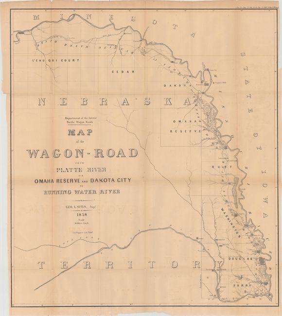
F. Map of the Wagon-Road From Platte River via Omaha Reserve and Dakota City to Running Water River. (23.7 x 26.3"). This highly detailed map extends from La Platte upriver to Niobrara at the Running Water River. Towns shown, as indicated by a street grid icon, include Omaha, De Soto, Decatur, Omadi, St. Johns, Ponca and Concord plus many smaller settlements. Also locates Indian Villages.
Disbound report and loose maps are housed in an attractive blue slip case. Report text is uncut.
References: Wagner-Camp #321; Wheat (TMW) #981, 982, 987 & 1004.
Condition: B
The folding maps are mostly good with toning, light offsetting, and numerous splits at fold intersections as is commonly seen. The top left corner of Map #2 where it was attached to the report has separated and been reattached with archival tape. Map #6 has a long fold separation spanning approximately half the map that has also been closed on verso with archival tape. Report text is mostly clean and bright. Slip case is excellent with minimal shelf wear.