Subject: References
Period: 1992-93 (published)
Publication:
Color: Printed Color
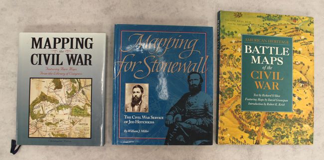
A. Mapping the Civil War - Featuring Rare Maps from the Library of Congress, by Christopher Nelson, published 1992 (8.3 x 10.6"). This interesting Civil War book features rare maps from the Library of Congress and a number of photographs and illustrations. These collected maps, some never published and many in manuscript form, show us a new face of this historic war. The captions are by Brian Pohanka, and the foreword is by Richard Stephenson. 176 pp. Hardbound in blue cloth with illustrated dust jacket. Condition: Contents and covers fine with a tiny amount of wear and soiling to the dust jacket.
B. American Heritage - Battle Maps of the Civil War, by Richard O'Shea, published 1992 (9.9 x 13.0"). This superb reference documents 17 of the major battles of the Civil War through maps and illustrations. The book provides a unique mix of never-before-published historic maps drawn in the aftermath of the battles, David Greenspan's pictorial maps first published in The American Heritage Picture History of the Civil War in 1960, aerial photography of battlefields, battle paintings by Don Troiani, and more. Bull Run, Antietam, Gettysburg, and Chattanooga are among the battles covered. Hardbound in black cloth with gilt title on the spine and an illustrated dust jacket. 176 pp. Condition: Contents very good with faint toning along the top of the sheets and a couple minor spots of soiling. Covers and dust jacket have minor wear.
C. Mapping for Stonewall - The Civil War Service of Jed Hotchkiss, by William J. Miller, published 1993 (9.4 x 11.3"). This is a signed copy of this fascinating chronicle of Jed Hotchkiss, a Virginia schoolteacher who served as a cartographer and topographer for Stonewall Jackson and Robert E. Lee's Army of Northern Virginia. His mapping of the Shenandoah Valley was integral to Jackson's Valley Campaign (1862). The book is filled with Hotchkiss' maps and various photographs and illustrations. Hardbound in gray cloth with an illustrated dust jacket. 176 pp. Condition: Contents tight and covers near fine. The dust jacket has a hint of wear.
References:
Condition: A
See description above.