Subject: Eastern Scotland
Period: 1693 (circa)
Publication: Great Britain's Coasting Pilot…
Color: Hand Color
Size:
22.1 x 17.4 inches
56.1 x 44.2 cm
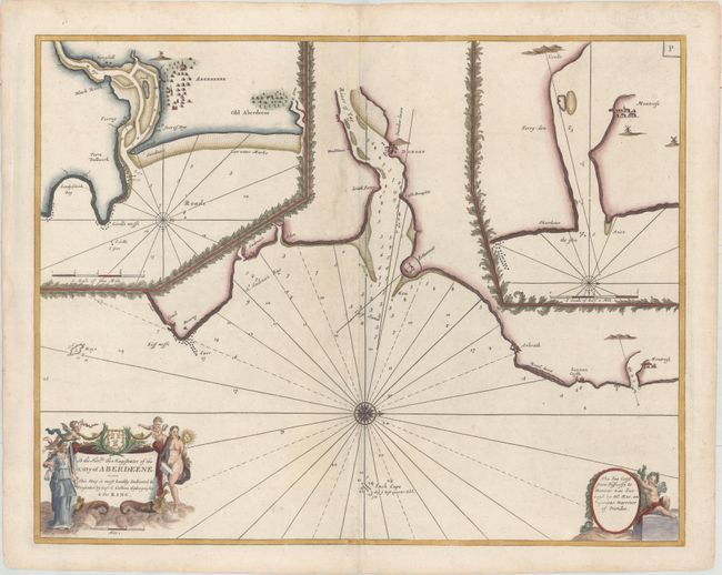
This handsome chart is centered on the city of Dundee and the River Tay, extending north to Montrose and south to Crail. Only a few place names are identified on the chart, including St. Andrews, the site of the oldest golf course in the world. There are excellent navigational details, such as soundings, rocks, shoals, and anchorages. At top left is a large inset of Aberdeen on the River Dee, and at right is an inset of Montrose on the River South Esk. The map is embellished with a compass rose orienting north to the right, and two decorative cartouches featuring Justice, putti, and a dedication to the Magistrates of the city of Aberdeen.
In 1681 Capt. Greenville Collins (fl.1669-1694) an officer in the Royal Navy was appointed by the Admiralty to make a complete survey of the coasts of Great Britain. Prior to this date the charts used by English mariners were copies of Dutch charts that had many inaccuracies. The task of surveying the entire coasts was formidable and took about 7 years, at the end of which only 46 surveys were finally used in an atlas titled "Great Britain's Coasting-Pilot Being a New and Exact Survey of the Sea-Coast of England," which was first published in 1693.
References: Verner (MCC-58) #36; Shirley (BL Atlases) M.COLL-1a #40.
Condition: A
A clean and bright example printed on heavy hand-laid paper with minor archival repairs along the centerfold and a crease in the left blank margin.