Subject: Scotland
Period: 1714 (dated)
Publication: The World Described; or, A New and Correct Sett of Maps
Color: Hand Color
Size:
39.9 x 23.6 inches
101.3 x 59.9 cm
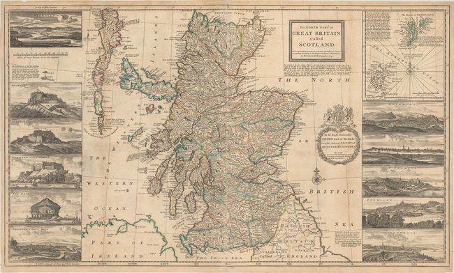
This handsome map of Scotland on two sheets shows great detail of the towns, counties, rivers, ports, and surrounding islands. Moll's map served as a significant improvement to the outline of Scotland as depicted in the previous century. The title notes that the map contains "many remarks not extant in any map" and indeed several of Moll's opinions are found throughout the map, as well as information on natural resources. A note below the title promotes the development of a fishery in Scotland as well as improved navigability of the rivers to access timber, explaining that these changes would eliminate the need for importing fish and timber from Norway and Newfoundland. A decorative wreath-style cartouche featuring the royal coat of arms contains a dedication to John Erskine, Earl of Mar. An inset at top right depicts the Shetland and Orkney Islands with notations on the abundance of fowl, herring, and sheep on the islands. Surrounding the map are superb bird's-eye views based on illustrations in Captain John Slezer's Theatrum Scotiae. The views show the towns of Edinburgh, Glasgow, St. Andrews, Stirling, Montrose, Aberdeen, and Fortrose (formerly Channery) and the castles of Edinburgh, Stirling, Dunnottar, and Bass Rock. This is the third state of five, with the imprint of John Bowles, Thomas Bowles, and John King, published circa 1730. There is a crack in the plate visible below the view of Edinburgh.
Herman Moll was one of Britain's most prominent cartographers of the first half of the 18th century. He emigrated from Germany and went to work as an engraver for Moses Pitt in 1678. Soon he joined one of London's most interesting social circles, which gathered at Jonathan's Coffee House, and included stock speculators, scientists, archaeologists, authors, pirates, and sea-captains. From these friends, Moll gained a great deal of privileged information that he compiled into his cartographic works. Moll's success and prosperity was due in part to his social connections and political astuteness, and to his distinctive style and quality workmanship. He produced a great number of often-innovative maps, charts, globes, atlases and geographies. His best known works are the large two-sheet maps produced for his World Described, which were also published separately.
References: Moir (Vol.1), p.180; Potter, p.95; Shirley (BL Atlases) T.MOLL-4b #11.
Condition: B+
Issued folding, now pressed with light soiling, minor toning along the folds, and professional repairs to some separations along the folds. There are several small chips and short tears in the blank margins, with three of these repaired tears just entering the map border.