Subject: Cartagena, Colombia
Period: 1741 (dated)
Publication:
Color: Black & White
Size:
23.1 x 16.8 inches
58.7 x 42.7 cm
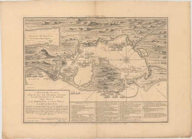
This scarce chart of Cartagena was published just days after the conclusion of the Battle of Cartagena, yet appears to show a certain victory for the British over the Spanish stronghold. In early May, while the British seemingly had the upper hand in the battle, Admiral Vernon dispatched Captain William Laws to London with news of their success thus far. Laws arrived on May 17 and relayed the information of the battle and a draft of the plan while at "Wills' Coffee House" on May 22. The chart was then engraved by William Toms and published one week later. Word of the British defeat in Cartagena did not reach Europe until June, but by that time maps and even commemorative medals had been made and distributed prematurely celebrating British victory.
The Battle of Cartagena was a large-scale attack by British and American colonial troops during the War of Jenkins' Ear, part of the War of the Austrian Succession. The attack was led by Admiral Edward Vernon, who, although unsuccessful in Cartagena, gained much acclaim for his victories elsewhere in the Caribbean. The chart highlights the defenses of the port and bay as well as the locations of various fleets.. The town of Cartagena is presented in a simple block pattern, with various forts and castles surrounding the bay, and numerous locations identified in a lettered and numbered key at bottom. The surrounding countryside is filled with hills and vegetation. A compass rose in the bay orients north to the left of the chart, and the bay is filled with notations of depth soundings, rocks and shoals. The locations of the fleets of Admiral Vernon, Admiral Chaloner Ogle, and Commodore Richard Lestock, are shown, with the locations of various shipwrecks also identified. The map is dedicated to Sir Charles Wager, who was First Lord of the Admiralty between 1733 and 1742 and was partially responsible for appointing Vernon to command the Jamaica Station. Engraved by William Henry Toms and published on May 29th, 1741 by Samuel Harding "on the Pavement in St. Martin's Lane." Adjacent to the publisher's imprint is the list price for the map: "Price One Shilling Plain, & Colour'd Two Shillings." Separately issued.
This chart is extremely rare, and we have only found 2 examples of this map for sale in the last 30 years.
References: Kapp (MCC-77) #74.
Condition: B+
A nice impression with minor toning and soiling and an archivally repaired centerfold separation in bottom blank margin. In the top blank margin there are a short centerfold separation and a minor separation along the platemark.