Subject: Texas
Period: 1860-87 (circa)
Publication:
Color: Hand Color
This lot includes five detailed maps of Texas showing the growth of the state over a twenty-seven year period including:
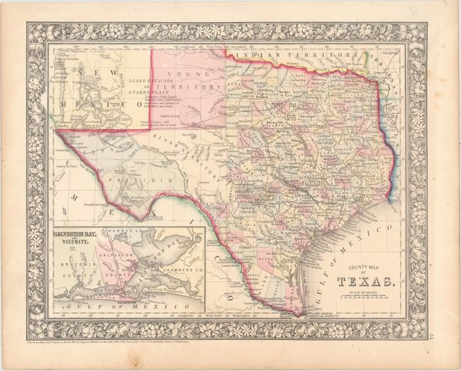
A. County Map of Texas, by Samuel Augustus Mitchell, Jr., dated 1860 (13.5 x 10.8"). One of the most attractive maps of the state of Texas, inset with a map of Galveston Bay, and Vicinity. West Texas is made up of Young Territory, Bexar Territory, El Paso and Presidio counties, and clearly shows the Llano Estacado or Staked Plain with a notation about the region being "destitu[t]e of both wood and water." Erath County is mistakenly identified as "Earth" County. The map shows trails, roads, a limited railroad system that extends only into Austin, and proposed railroads indicated by dashed lines. The map is surrounded by a fine floral border. Copyright date 1860, published circa 1864. The county development is up-to-date for 1864 as Dawson County, abolished in 1866, is included. Condition: Clean and bright with a few minor stains confined to the blank margins. (A)
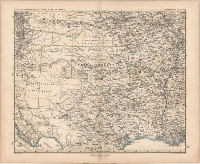
B. Vereinigte Staaten von Nord-Amerika in 6 Blattern, Bl. 5, by Augustus Herman Petermann, from Stieler's Hand-Atlas, dated 1872 (16.4 x 13.2"). This highly detailed German map covers the region from St. Louis west to Colorado Springs and south to New Orleans, Galveston and El Paso (the southern tip of Texas is not shown). It is densely filled with place names, roads, railroads, rivers and topography. Shows numerous Indian reservations including the Osage, Cherokees, Creek, Chickasaw and Choctaw. Condition: Light toning along the centerfold, faint offsetting, and short centerfold separations at top and bottom. (B+)
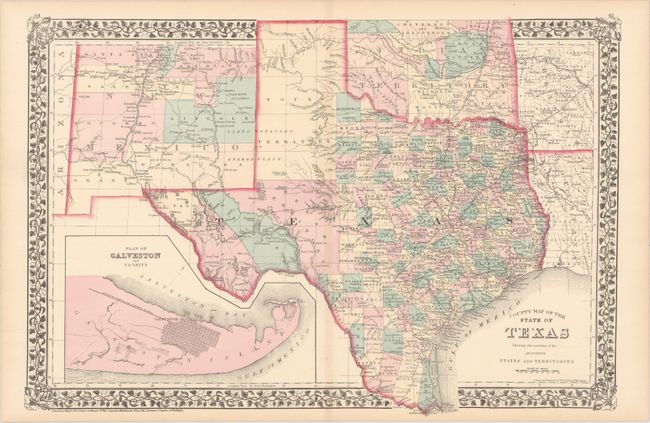
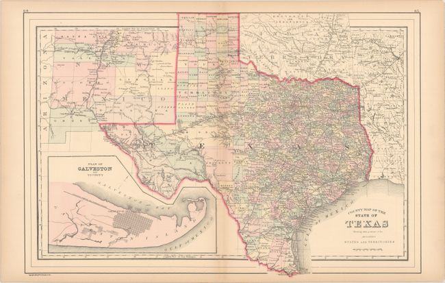
C. County Map of the State of Texas Showing Also Portions of the Adjoining States and Territories, by Samuel Augustus Mitchell, Jr., from General Atlas, dated 1876 (21.3 x 14.6"). This fine double-page map of Texas extends to include most of New Mexico to above Santa Fe and the adjoining parts of Oklahoma, Arkansas and Louisiana. The map presents an excellent view of the county development with only the large regions of West Texas yet to be organized. Galveston’s role as a main port of entry is obvious as it is depicted in a large inset. The Llano Estacado, or Staked Plain, is shown extending from the New Mexico Territory through the Texas panhandle. Indian Territory is divided into several large Indian nations and reservations. The map is surrounded by Mitchell's distinctive grapevine border. Drawn and engraved in Philadelphia by W. H. Gamble. Condition: Fine, with minor toning along the edges of the sheet. (A)
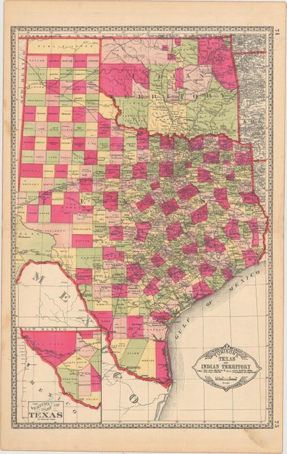
D. Tunison's Texas and Indian Territory, by H.C. Tunison, circa 1890 (13.0 x 19.7"). In Tunison's style, this is a finely lithographed map with original bright coloring. By this period most mapmakers had adopted printed color rather than the more labor intensive hand coloring employed here. It is decorated with a Victorian style border and title cartouche, which gives the population of Texas as 1,591,749 and no population reported for Indian Territory. At lower left is an inset "The Western Part of Texas on Reduced Scale." The panhandle of Oklahoma is Public Lands. Indian Territory is clearly divided into about 20 different Indian lands. Green County, originally established in 1860, is here unnamed and still part of Texas. It was abolished and awarded to Indian Territory by a Supreme Court decision in 1896. There is good detail of railroads with all stops located and named. Tunison's maps were printed on both sides; on the verso are single-page maps of Nebraska and Alabama. Condition: Mostly clean and bright with a little marginal soiling. (A)
E. County Map of the State of Texas Showing Also Portions of the Adjoining States and Territories, by William M. Bradley [& Bros.], dated 1887 (21.4 x 14.4"). This is an update to map "C" with the railroad network extending west to Laredo and El Paso. Condition: Faint toning along the centerfold and sheet edges, otherwise fine. (A)
References:
Condition:
See description above.