Subject: California
Period: 1852 (dated)
Publication:
Color: Black & White
Size:
13.5 x 16.9 inches
34.3 x 42.9 cm
The Office of Coast Survey is the oldest U.S. scientific organization, dating from 1807 when Congress directed that a "survey of the coast" be carried out. By 1836, it was called the U.S. Coast Survey and in 1878, the name was changed to the U.S. Coast and Geodetic Survey. Today the Office of Coast Survey is a division of the National Oceanic and Atmospheric Administration NOAA.
The survey teams, composed of civilians as well as Army and Naval officers, charted the nation's waterways and produced a wide array of reports, survey charts, hydrographic studies of tides and currents, astronomical studies and observations, and coastal pilots. These charts are an important record of the changing nature of the nation's coastlines. In additional to coastal charts, the U.S. Coast and Geodetic Survey produced land sketches, Civil War battle maps, and the early aeronautical charts.
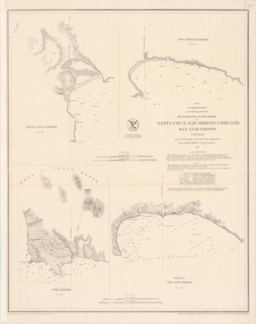
This detailed coast survey shows several important harbors along the central coast of California, including Santa Cruz, San Luis Obispo, San Simeon, and Coxo (just south of Pt. Conception). There are notations on breakers, reefs, the sea floor, and other navigational details. The topography of the land along the coast is illustrated by hachure. The survey was completed under the command of Lieut. James Alden. Outlines and topography engraved by H.C. Evans and Max Strobel, with lettering engraved by H.M. Knight.
References:
Condition: A
A clean and bright example, issued folding and now pressed and backed in tissue. The left margin has been extended to accommodate framing.