Subject: Colonial North America & Caribbean
Period: 1720 (circa)
Publication:
Color: Hand Color
Size:
22.6 x 18.8 inches
57.4 x 47.8 cm
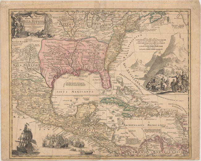
This superb map covers the region from the Great Lakes and Nova Scotia through Central America, the Caribbean and Venezuela, and from New Mexico (naming Taos and Santa Fe) to the eastern seaboard. The map is based largely on Delisle's map of 1703 (Carte du Mexique et de la Floride), depicting the social, political, and economic outcomes from the War of the Spanish Succession, also known as Queen Anne's War. The British colonies are shown confined east of the Appalachians and extending south almost to St. Augustine, deep into Spanish-claimed territory. The map itself is filled with settlement place names, Indian tribes and villages. In present-day Texas, La Salle's ill-fated colony, and el passo (El Paso) are noted. Sea routes of treasure fleets from Vera Cruz and Cartagena to Havana and Spain are outlined. Richly embellished, a fine title cartouche depicts two native figures with items to trade, such as hides and blankets. In the Atlantic, there is a large scene of extensive gold mining operations, with Indians bringing their treasures to fill the Europeans' chest. Off the Pacific coast of Mexico is yet another opulent engraving of a raging sea battle, reminiscent of the battles fought in Queen Anne's War.
References: Van Ermen, p.42; Manasek #72; Martin & Martin #17; Portinaro #CXV.
Condition: B+
A nice impression with original color on watermarked paper. There is light toning, minor soiling, and professionally repaired centerfold separations at top and bottom.