Subject: Asia
Period: 1691 (published)
Publication: Atlante Veneto
Color: Hand Color
Size:
34.7 x 24.1 inches
88.1 x 61.2 cm
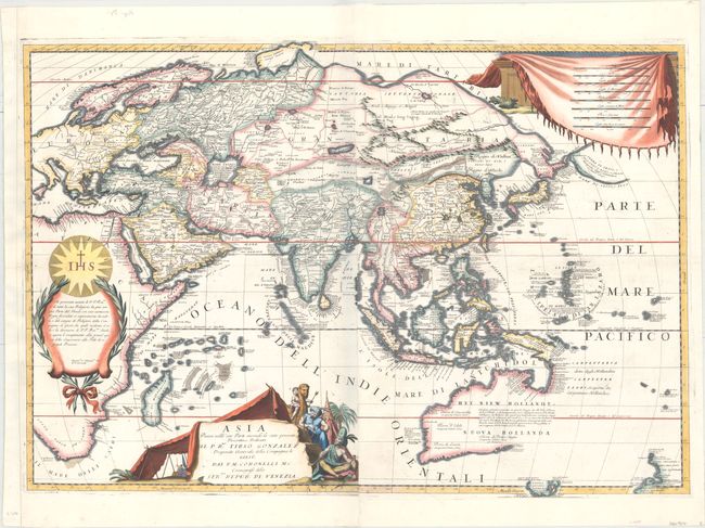
This stunning large-scale map of the Asian continent extends through the Indian Ocean, Southeast Asia, and Australia. Coronelli's map was very advanced for its era thanks to the extensive geographical knowledge of the Jesuits, who are acknowledged in a large cartouche on the left sheet. Notable are the detailed but incomplete coastlines of Australia, Tasmania, and part of New Zealand, reflecting Abel Tasman's important discoveries from his voyage in 1642-43. North of Japan and Korea is a landmass attached to the continent called Tartari de Yupi. Just east of this landmass, across a narrow Stretto de Vries, is Terra di Iesso, o' Ieco, Yedco, Esso, et Sesso. Novaya Zemlya is depicted without a clearly delineated southern coastline. Place names appear in both Italian and Dutch. Eight distance scales are enclosed in a large drape cartouche at top right. The title cartouche at bottom features figures in traditional Asian dress, a camel, a palm tree, and a tent. On two sheets, joined.
References: Shirley (BL Atlases) T.CORO-7a #8 & 9; Tooley (MCC-23) #54, plt. XXIII; Yeo #73.
Condition: A
A fine impression in attractive later color with minor printer's ink residue and professional repairs to a tear around the dedication to the Jesuits and to a small worm hole on the second sheet. The left margin has been extended to better accommodate framing.