Subject: Western United States
Period: 1836-49 (circa)
Publication:
Color: Black & White
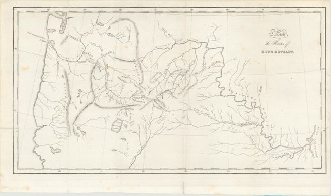
A. Sketch of the Routes of Hunt & Stuart, by Washington Irving, circa 1836 (18.0 x 9.6"). Describing an expedition launched just a few years after Lewis & Clark's epic journey, this map covers the same region - from the junction of the Mississippi and Missouri, up the Missouri, across the Rocky Mountains and through the Pacific Northwest, extending to well below Lake Bonneville Salt Water. The southern portion of the map is mostly blank except for a long, straight Colorado of the West with many tributaries originating in the Rockies. The Great Basin region has three lakes and a few land-locked rivers. The routes of the two explorers are delineated with dotted lines with Stuart's party reaching all the way to Astoria near the mouth of the Columbia River. Wheat says "for what it purports to be it is an excellent map." The map is the result of a commercial exploration directed by John Jacob Astor. The expedition was sent in 1811 to seek an overland route to the Pacific. Washington Irving was commissioned by Astor to write the account of his company's effort to create a settlement in Oregon. The work and this map were not published until 1836. Reportedly engraved by Carey, Lea & Blanchard, but no attribution is given on the map. Ref: Wheat [TMW] #419. Condition: Issued folding with a few faint spots and a couple of short fold separations that have been closed on verso with archival tape.
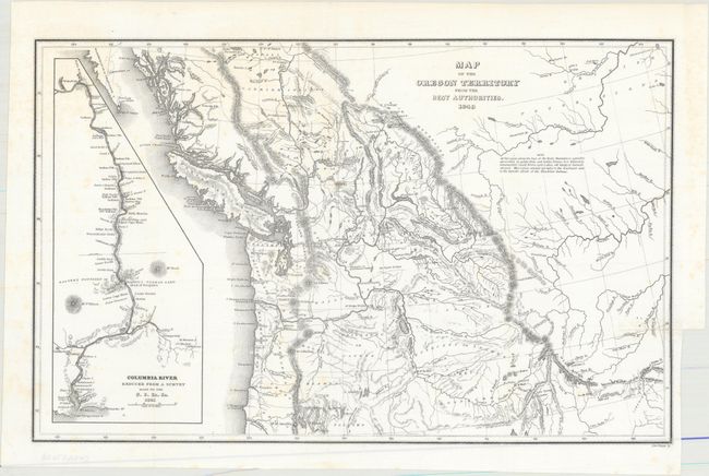
B. Map of the Oregon Territory from the Best Authorities, by Charles Wilkes, dated 1849 (13.1 x 8.4"). This is the reduced edition of Wilkes' map that was a major contribution to American cartography and the most detailed map of the region north of the Sacramento River. It provided Americans with an accurate view of an area still virtually unknown in the mid-nineteenth century. Wilkes stood with Senator Lewis Linn in the famous 54-40 or Fight controversy, supporting the view that the northwest boundary of America should be 54° 40' North. This map was used to illustrate that his claim was based on 'topographical' grounds and was instrumental in setting the scene for American interests in the territory. The map covers the region from Fraser's Fort and Fort St. James in British Columbia south to the upper Sacramento River, and from the Pacific coast to the Black Hills east of the Rocky Mountains. The map provides excellent detail of the region including dozens of forts, watershed, and other place names. A large inset map "Columbia River Reduced from a Survey Made by the U.S. Ex. Ex. 1841" depicts the river from Ft. Walla Walla to its mouth, where one of Wilkes' ships, the Peacock, was lost on the infamous Columbia Bar. It also features details of missions, Indian villages, and the major mountains. Engraved by Edward Yeager. Ref: Wheat (TMW) #655; Hayes 199. Condition: Issued folding with a 0.5" fold separation closed on verso with archival material and a few faint spots.
References:
Condition: B+
See description above.