Subject: North America
Period: 1844 (dated)
Publication: Olney's School Geography
Color: Hand Color
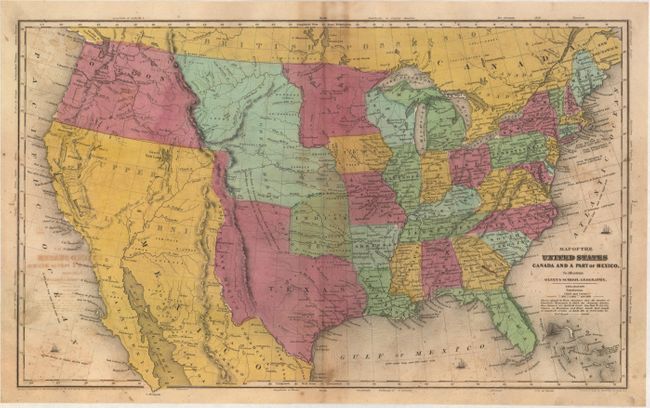
A. Map of the United States Canada and a Part of Mexico. To Illustrate Olney's School Geography, (17.5 x 10.8"). This map shows the Independent Republic of Texas in its last full year as a republic. The panhandle extends well to the north into present-day Colorado. Along the western border of Texas is a small region named Santa Fe or New Mexico. A huge Nebraska Territory occupies the northern plains with Indian Territory to its south. Mexico controls California and the Southwest, which is labeled Upper California, while the Baja is Old California. Oregon Territory reaches to the Continental Divide. The map has terrific territorial configurations and is filled with information on forts, Indian tribes, waterways and more. Copyright below neatline by D.F. Robinson. Drawn and engraved by Sherman & Smith, N.Y.
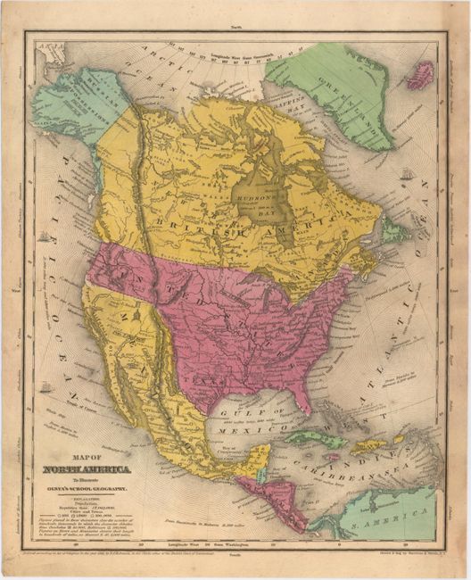
B. Map of North America to Illustrate Olney's School Geography, (8.6 x 10.6"). This map also features a large Independent Republic of Texas with a long stovepipe panhandle and Austin shown as the capital. Locates Santa Fe, San Antonio de Bexar, and Houston. Above Texas is the Great American Desert. The United States extends to the Pacific with Astoria, Willamette, and Ft. Wallah-Wallah named. Mexico controls California and the Southwest while Alaska is Russian Possessions with the Aleutian Peninsula labeled Alaska. Cook's Inlet is well shown. States are not shown in the U.S. or Mexico, but the population of each country is on the map. A population of 500,000 is given for Texas. Numerous Indian tribes and major towns are named. There is good detail of major rivers, and a vague idea of the "Rocky or Oregon" mountains. The Great Basin is here called the Sandy Plains.
References:
Condition: B
Original color with light soiling and scattered foxing. The double-page map of the United States also has light offsetting.