Subject: Kamchatka, Japan, Macao
Period: 1780-85 (circa)
Publication:
Color: Black & White
Captain James Cook (1728-1779) is best known for his three voyages to the Pacific (1768-71; 1772-75; and 1776-79). His discoveries radically changed the western understanding of the world in the late 18th century. He was the first to circumnavigate and chart New Zealand and provided the earliest European accounts of exploration along the eastern coast of Australia and the Hawaiian Islands. On February 14th, 1779, he was killed on Hawaii after attempting to kidnap the chief of the island.
Many contemporary accounts of Cook’s voyages, including charts and engravings, appeared in the late 18th century. The first official account of Cook’s first voyage was published in 1773 by John Hawkesworth in Volumes II and III of An Account of the Voyages Undertaken by the Order of His Present Majesty for Making Discoveries in the Southern Hemisphere... William Strahan and Thomas Cadell published the first official accounts of the second and third voyages in 1777 and 1784. Accounts of his exploration were subsequently translated into French, German, and Dutch.
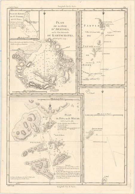
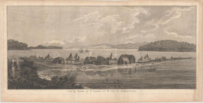
This lot includes a copper engraving with detailed maps of Kamchatka, part of Japan, and the island of Macao, as well as an engraving based on Captain Cook's explorations in Kamchatka. The Kamchatka map includes an inset: Plan du Havre de St. Pierre et St. Paul. Soundings, anchorages, and topographical details are shown. Engraved by Andre. The engraving is based on the work of John Webber, a young artist who accompanied Captain James Cook on his third voyage to the Pacific in 1776-1780. Webber, who was fascinated with the natives and their habitations, took the opportunity to draw them whenever Cook's ships anchored in harbors throughout the Pacific and Pacific Northwest. This particular engraving depicts a bustling harbor scene in Kamchatka, with excellent detail of the native's dwellings.
A. Plan de la Baye d'Awatska... [on sheet with] Plan du Typa ou de Macao [and] Partie du Japon ou Nipon, by Rigobert Bonne, from Atlas Encyclopedique, circa 1780 (9.3 x 13.8"). Condition: On a watermarked sheet with minor offsetting . (A)
B. Vue du Havre de St. Pierre et St. Paul, au Kamtschatka, by Cook/Benard, from Troisieme Voyage De Cook, ou Voyage a l'Ocean Pacifique..., circa 1785 (19.8 x 8.8"). Condition: A nice impression with several extraneous creases in the middle of the sheet, light scattered foxing, and toning along sheet edges. The sheet has been remargined at right with old paper. (B)
References:
Condition:
See description above.