Subject: France
Period: 1758-65 (published)
Publication:
Color: Black & White
An interesting set of maps focused on French fortifications along the coast during the Seven Years' War, issued in various British periodicals. The maps include:
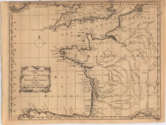
A. A Complete Chart of the Coast of France. From Ostend, to Cape Finisterra, Including the Opposite Coast, of the British Channel, from Gentleman's Magazine, published 1758 (10.1 x 8.0"). Covers the western coast of France from Calais to Cape Finisterra. Shows good coastal detail and only the river system inland. Ref: Jolly #GENT-123. Condition: Two short edge tears at top have been closed on verso with archival tape. (B+)
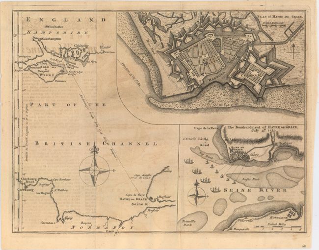
B. [Part of the British Channel] [on sheet with] Plan of Havre de Grace [and] The Bombardment of Havre de Grace, July 4th 1759, from Gentleman's Magazine, published 1759 (10.1 x 7.7"). Detailed sheet featuring three maps of the fortified city of Havre de Grace. Shows the track of Admiral Rodney from Portsmouth, England in July 1759. Ref: Jolly #GENT-131. Condition: (B+)
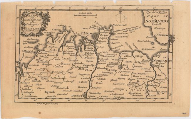
C. A Map of the North Eastn. Part of the Province of Brittany, by Thomas Kitchin, from London Magazine, published 1758 (6.9 x 4.3"). Small map of northern Brittany from Avranches to Saint Brieuc. Shows fortified cities, towns and churches. Ref: Jolly #LOND-138. Condition: (B+)
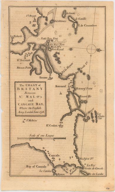
D. The Coast of Britany Between St. Malo's and Cancale Bay, Where the English Army Landed Iune 1758, from Gentleman's Magazine, published 1758 (4.3 x 7.6"). Small map of northern Brittany roughly centered on St. Malo. Towns are identified by tiny buildings with numerous islands depicted off the coastline. North is oriented to the right. Ref: Jolly #GENT-117. Condition: (B+)
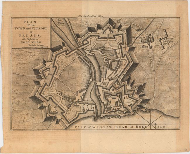
E. Plan of the Town and Citadel of Palais, the Capital of Bell Isle, from Gentleman's & London Magazine, published 1761 (9.2 x 6.1"). Depicts the fortified city of Palais on the island of Belle Ile off the coast of Brittany. Identifies the citadel, guard house, village and ancient palace. Ref: Jolly #GAL-87. Condition: Moderate toning and offsetting. (B)
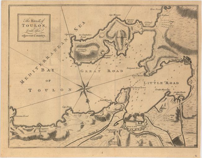
F. The Roads, of Toulon, with the Adjacent Country, from Gentleman's Magazine, published 1759 (10.3 x 7.8"). Detailed map of the bay and city of Toulon along with surrounding fortifications, castles and towns. A lovely compass rose shows north oriented at bottom. Ref: Jolly #GENT-127. Condition: (B+)
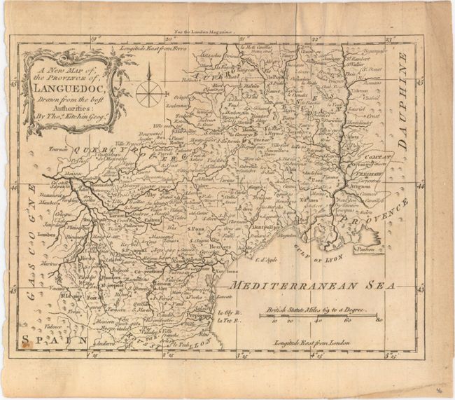
G. A New Map of the Province of, Languedoc, Drawn from the Best Authorities, by Thomas Kitchin, from London Magazine, published 1765 (8.7 x 6.8"). Detailed map of this region of southern France including the cities of Montpelier, Perpignan and Toulouse. Shows numerous place names, the river systems and topography. Ref: Jolly #LOND-246. Condition: Minor extraneous creases adjacent to a fold and a narrow left margin as issued. (B)
References:
Condition:
All issued folding with light toning and offsetting. See description for additional details.