Subject: Atlantic Ocean
Period: 1715 (published)
Publication: Atlas de la Navigation et du Commerce…
Color: Hand Color
Size:
22.2 x 19.1 inches
56.4 x 48.5 cm
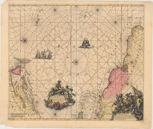
Magnificent sea chart of the western Atlantic Ocean showing the coastlines of North America from Cape Charles, Maryland to Newfoundland, and the West Indies to the northern coast of Brazil. The chart is based on that of Theunis Jacobsz, circa 1650, with few changes except for an improved (although still rudimentary) depiction of the Chesapeake Bay. Oriented by two compass roses with north to the left; the Azores and Cape Verde Islands are at the top of the map. It is richly decorated with two large cartouches with the title in Latin and Dutch. The central cartouche is surrounded by Mercury, a native riding an alligator, mermen and sea monsters. The corner cartouche with Dutch title features figures of explorers, natives, and exotic animals, including an armadillo. In the sea are sailing ships, including a raging sea battle, rhumb lines and two compass roses. This is the third state with the addition of Mariland, Renard's imprint replacing that of de Wit, and Fol. 26 added at top right.
First published circa 1675, de Wit's sea atlas, Orbis Maritimus ofte Zee Atlas, contained 27 charts from the North Pole to North and South America. The charts all appear to have been engraved by Romain de Hooghe and are splendid examples of Dutch marine works. The atlas was reprinted with amendments by Louis Renard in 1715, by Reinier and Josua Ottens in 1739 and 1745, and finally by the widow of van Keulen in 1802.
References: Burden #467; McCorkle #675.9; Shirley (BL Atlases) M.REN-1a.
Condition: B+
A fine impression with original color in the map and later color in the cartouches. There is a small burn hole near the center of the map, and centerfold separations that enter map 0.5" at top and 1.5" at bottom have been archivally repaired. In the blank margins there are several small chips, extraneous creases, and a few short tears that have been closed on verso with archival tape, and only one of which touches the neatline at bottom.