Subject: Southwestern United States & Mexico
Period: 1850 (published)
Publication: Senate Ex. Doc. No. 34, 31st Congress, 1st Session
Color: Black & White
Size:
5.6 x 8.9 inches
14.2 x 22.6 cm
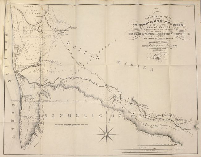
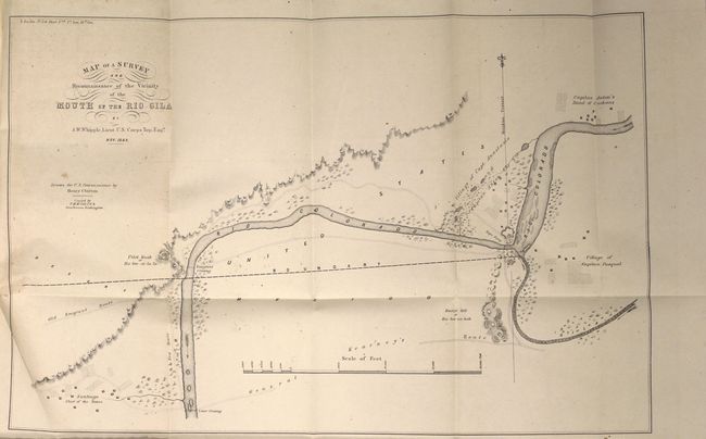
This lot includes four maps critical in determining the beginning points for the survey of the United States/Mexican boundary. Of particular importance are the two folding maps:
Topographical Sketch of the Southernmost Point of the Port of San Diego, and the Measurement of the Marine League for Determining Initial Point of the Boundary between the United States and Mexican Republic (22.8 x 17.5"). This was the critical map of the Mexican Boundary Survey. Initial work had broken down over a Mexican demand that Mexico be given the port of San Diego, and the determination of the length of a league. It provides interesting detail in the vicinity of San Diego and anchors the border determination for this area. This map is full of information, including the new Camp Rough & Ready, which became a gold mining town and then seceded as a republic for about three months in 1850, until the neighboring towns started having 4th of July celebrations and they felt left out and rejoined the country. The map is visually very attractive with calligraphy title and a large compass rose. Marine leagues are described on the map as 5564 meters - the standard today. Surveyed by Andrew B. Gray, John B. Weller, Commissioner.
Map of a Survey and Reconnaissance of the Vicinity of the Mouth of the Rio Gila (16.5 x 11"). This map illustrates a critical aspect of the Mexican Boundary Survey (following the Treaty of Guadeloupe Hidalgo) with the determination of an agreed upon point (the middle of the Rio Gila where it enters the Colorado) to anchor the boundary line in the east. Shows the villages of Captain Pasqual, Capt. Anastasio, and Captain Anton in the vicinity of Yuma. Also shows the Old Emigrant Route and General Kearney's Route. Locates a rope crossing, the emigrant crossing and the lower crossing east of Santiago. An important and historical map that is finely engraved with good detail along the rivers.
Included with the two folding maps is 75 pages of text from the report as well as two small maps (each approx 5.5 x 8"): "Plan of the Junction of the Colorado and Gila Rivers…" and an untitled map of the same geography showing the boundary line.
References: Wheat (TMW) #616, 650, 652 & 653.
Condition: B+
The maps are clean and bright with just a few spots of foxing. Disbound text is very good with light toning.