Subject: United States
Period: 1848-83 (dated)
Publication:
Color: Black & White
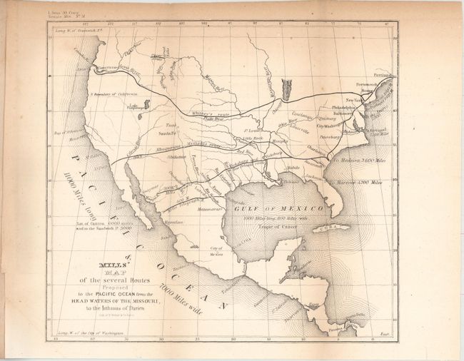
A. Mills' Map of the Several Routes Proposed to the Pacific Ocean from the Head Waters of the Missouri, to the Isthmus of Darien, by U.S. Government, published 1848 (8.9 x 8.2"). This interesting and historically important map was one of the first to promote to Congress the idea of a trans-continental railroad. The map shows four major routes; Whitney's route (connecting New York, Chicago and Astoria), the Albuquerque-Memphis route (connecting Memphis, Little Rock, Albuquerque and San Diego), the Vicksburg and New Orleans route (from New Orleans to Vicksburg and on to San Antonio and Guaymas) and finally the Mills Telegraph Route (cutting across Texas and Mexico from Matagorda to an unnamed terminal in the vicinity of Los Mochis). Robert Mills proposed linking the two coasts by rail as early as 1819 and was among the project's most ardent supporters. Included with the map is the disbound 7 pp. report. Ref: Wheat (Gold) #54; Wheat (TMW) #564. Condition: Light toning along the top border and vertical folds. (B+)
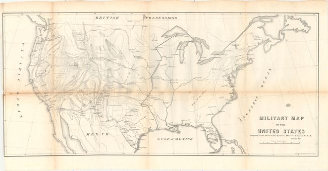
B. Military Map of the United States Prepared in the Office of the Quarter Master General U.S.A., by U.S. War Department, dated 1857 (30.0 x 13.6"). This interesting map shows how quickly the military establishment in the West grew following the war with Mexico. A black line shows the Extreme line of outposts in 1845, which is well east of the 100th meridian. The western region is now divided into military districts and numerous forts for protection of the frontier are shown therein. The topography and river systems of the West are shown along with several recent exploration routes. Wheat called this map very illuminating, and it would be a fine addition to any collection focusing on the mapping of the West or military development. Ref: Wheat (TMW) #929. Condition: Issued folding with light scattered foxing, toning along the horizontal fold, and several short fold separations that have been mostly closed on verso with archival tape. (B)
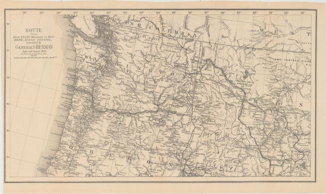
C. Route from Fort Ellis Montana to Fort Hope, British Columbia, Travelled by General Sherman July and August 1883, as Shown by Heavy Black Line, by U.S. Government, dated 1883 (27.4 x 15.3"). A heavy dark line depicts General Sherman's route from Yellowstone to Fort Hope, B.C. He led his troops through the sites of many native battles in his final year as the Head of the Army, retiring in November of 1883. The map has fine detail of watershed in the Northwest. It extends as far east as Bozeman to show most of Yellowstone National Park, and south to show Point Orford in Oregon. Roads, Indian reserves, towns, rivers and the rail lines are noted. Condition: Issued folding with a tiny binding tear at left that just passes the neatline and has been archivally repaired (A).
References:
Condition:
See description above.