Subject: References
Period: 1972-79 (published)
Publication:
Color: Black & White
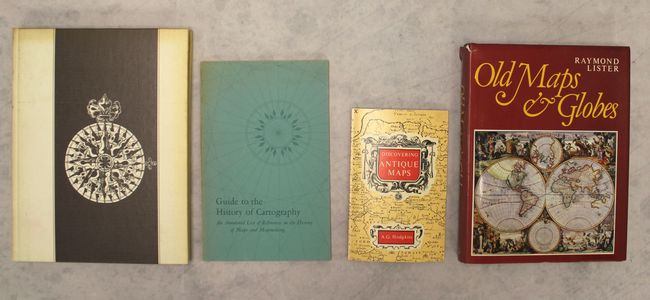
A. A la Carte - Selected Papers on Maps and Atlases, by Walter W. Ristow, published 1972 (8.1 x 10.6"). This reference features 20 illuminating essays from 9 different experts in the field of cartography. Subject include Apian's 1530 world map, Mercator's atlas of 1595, maps of early America, Captain John Smith's historic map of Virginia, the Walker-Washington map, and John Melish's map of the United States. Most of these essays originally appeared in the Quarterly Journal of the Library of Congress. The collection was edited by the late Walter W. Ristow, former Chief of the Geography and Map Division of the Library of Congress. 232 pp. with plenty of black and white illustrations. Hardbound. Condition: Contents fine. Covers are lightly soiled and toned. (B+)
B. Guide to the History of Cartography - An Annotated List of References on the History of Maps and Mapmaking, by Walter W. Ristow, published 1973 (5.9 x 9.1"). This list of 398 references on cartography includes a preface by Ristow and a thorough index. 96 pp. Paperback with light blue pictorial covers. Condition: Minor wear to the covers and toning along the spine, otherwise fine. (A)
C. Discovering Antique Maps, by Alan G. Hodgkiss, published 1977 (4.6 x 7.0"). This introductory history of early mapmaking in the British Isles covers the 16th, 17th, and 18th centuries. Although small, it touches on many facets of early mapmaking beginning with a discussion on technical terms. Each component of a map is described including the various decorative elements. Paperback, 72 pp. including illustrations in B&W. This is the third edition, published in 1977. Condition: Contents fine. There is minor wear to the covers. (A)
D. Old Maps and Globes with a List of Cartographers, Engravers, Publishers and Printers Concerned with Printed Maps and Globes from c. 1500 to c. 1850, by Raymond Lister, published 1979 (7.7 x 9.9"). This excellent resource outlines the history of maps and charts, map production, and how to date maps and documents using watermarks. It includes a section on globes and armillary spheres, as well as a most useful biographical list of cartographers, engravers, printers, and publishers from 1500-1850 that in some cases has better information than Tooley's Dictionary. 256 pp., 59 plates. Hardbound in red cloth and illustrated dust jacket. Revised edition. Condition: Contents fine. Covers near fine with minor wear along the spine. There are a few short tears and toning along the spine on the dust jacket. (A)
References:
Condition:
See description above.