Subject: New York
Period: 1901 (published)
Publication:
Color: Printed Color
Size:
11.3 x 9.3 inches
28.7 x 23.6 cm
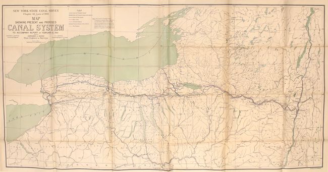
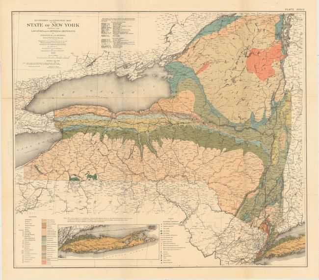
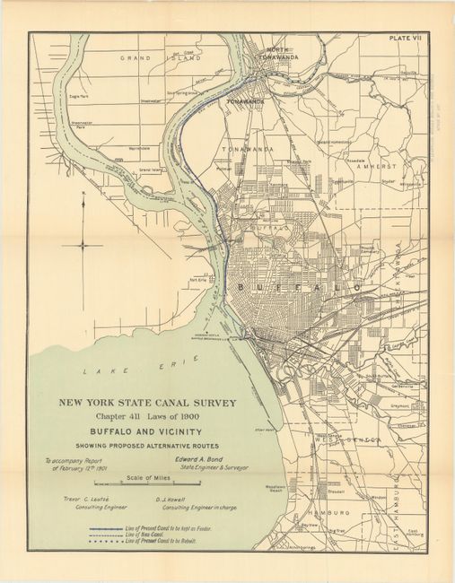
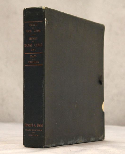
This set of 35 maps, profiles, and plates is from the Report on the Barge Canal from the Hudson River to the Great Lakes by Edward Bond, State Engineer and Surveyor. Of particular interest is the very large Map of the Canal System of the State of New York (61 x 31”) which depicts both current and proposed canal lines in solid and dotted blue overprinting. The map is drawn on a scale of 5 miles per inch and is based upon the earlier Preliminary Geologic Map of New York by James Hall. Also included is the colorful and comprehensive Economic and Geologic Map of the State of New York Showing the Locations of Its Mineral Deposits (26.2 x 23.2”) by Frederich Merrill. The geology of the map was based on an Agricultural and Geological Report of 1844 with additions and corrections from numerous sources that are listed in a table. One legend explains symbols used to show the locations of water resources, gas and oil fields, clay deposits and stone quarries. Another legend identifies 25 different geological types through coloring. The full list of maps (size varies) includes:
Plate No. I—Map of the Canal System of the State of New York.
Plate No. II—Alternative Routes, Cohoes and Vicinity.
Plate No. Ill—Alternative Routes, Rome and Vicinity.
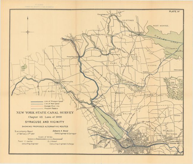
Plate No. IV—Alternative Routes, Syracuse and Vicinity.
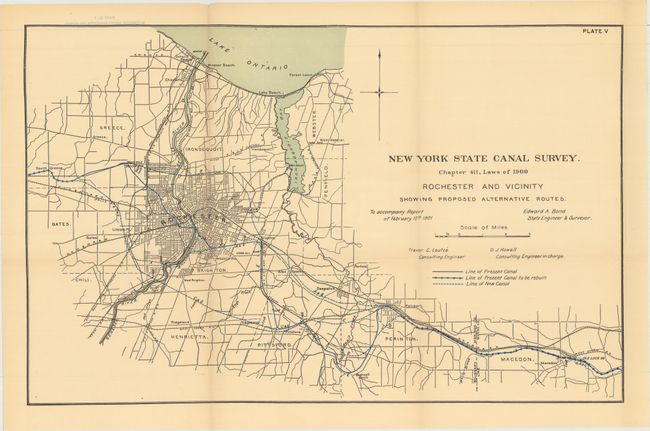
Plate No. V—Alternative Routes, Rochester and Vicinity.
Plate No. VI—Alternative Routes, Niagara River and Vicinity.
Plate No. VII—Alternative Routes, Buffalo and Vicinity.
Plate No. VIII—Profile of Water Surfaces via Mohawk River.
Plate No. IX—Profile of Water Surfaces, Present Erie Canal, Rexford Flats to Oneida Lake.
Plate No. X—Profile of Water Surfaces, Champlain Canal.
Plate No. XI—Profile of Water Surfaces, Oswego Canal.
Plate No. XII—Profile of Water Surfaces, Lockport-Olcott Route.
Plate No. XIII—Cross Sections for 12-foot Depth of Water.
Plate No. XIV—Cross Sections for 7-foot Depth of Water.
Plate No. XV—Cross Sections for 9-foot Depth of Water.
Plate No. XVI—Standard Highway Bridge, Erie and Oswego Canals.
Plate No. XVII—Standard Farm Bridge, Erie and Oswego Canals.
Plate No. XVIII—Standard Highway Bridge, Champlain Canal.
Plate No. XIX—Standard Farm Bridge, Champlain Canal.
Plate No. XX—Standard Lift Bridge, Erie Canal.
Plate No. XXI—Dive Culvert for 12-foot Depth of Water.
Plate No. XXII—Standard Lock for Erie and Oswego Canals.
Plate No. XXIII—Standard Lock for Champlain Canal.
Plate No. XXIV—Flight of Locks at Cohoes.
Plate No. XXIV-A—Plan of Wiring System for Locks.
Plate No. XXV—Lower Lock Gate for 20-foot Lift.
Plate No. XXVI—Drainage Basins of Mohawk, Black and Oneida Rivers.
Plate No. XXVII—Rainfall Data, Etc., In Central and Eastern Part of State.
Plate No. XXVIII—Drainage Basins of Mohawk and Oneida Rivers, with Rainfall Contours, Etc.
Plate No. XXIX—Relation of Rainfall to Run-off In Mohawk Valley in Different Months.
Plate No. XXX—Reservoir Sites ami Feeder, West Caiiada and Nine Mile Creeks.
Plate No. XXXI—Profiles Showing Portions of Erie ami Champlain Canals Gauged in 1900.
Plate No. XXXII—Typical Diagrams Relating to Canal Gauging.
Plate No. XXXIII—Flood Discharge in Relation to Size of Drainage Basin.
Plate No. XXXIV—Geological Map of State.
The plates are housed in an open-ended, blue cloth slipcase.
References:
Condition: A
The maps, issued folding, are all near fine to fine with some occasional faint toning and tiny splits at fold intersections. The slipcase has light shelf wear with a small damp stain along one edge. Ribbon tie that closes the opening to the slipcase is not present.