Subject: World
Period: 1724 (dated)
Publication:
Color: Hand Color
Size:
21.4 x 15.3 inches
54.4 x 38.9 cm
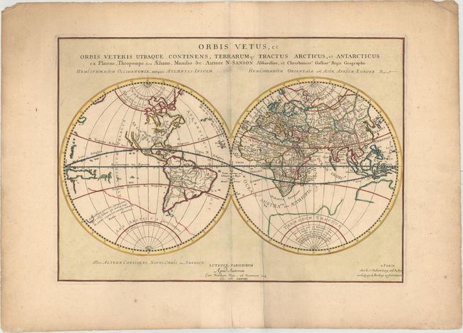
This handsome double-hemisphere world map depicts the ancient world, with classical place names in the eastern hemisphere, and just a few mythical place names in the western hemisphere. The Great Lakes are open-ended in the west, and there are spurious mountains and rivers throughout the western hemisphere. This map was originally published by Sanson in 1657, and was copied for this edition with numerous updates, published by Robert de Vaugondy. Although California is no longer shown as an island, the northwest coast of North America remains blank. As with previous editions, the partially delineated outline of a large Antarctic continent fills the southern hemisphere, although a new coastline appears well south of New Zealand, with a quote from Marcus Manilius' Astronomica, the earliest known treatise on astrology. Australia, New Zealand, and what appears to be part of New Guinea or the Solomon Islands are also partially delineated and unnamed. A very uncommon map.
References: cf. Shirley #562.
Condition: B+
A dark impression and attractive color on watermarked paper with wide margins. There is an extraneous crease adjacent to centerfold, one tiny pinhole in the image, and minor soiling.