Subject: Eastern Asia
Period: 1858 (dated)
Publication:
Color: Hand Color
Size:
20.9 x 13.9 inches
53.1 x 35.3 cm
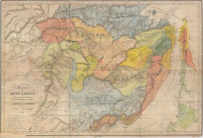
This map by Schrenck, Maximowicz and Lamochwaloff depicts the region to the north of Vladivostock, covering northeastern China and eastern Russia. It has been meticulously colored and annotated in manuscript to delineate tribal lands including the Manchus, Mongols, Birars, Oronschons, etc. in the region of the Amur River. Pencil notations dated 1866 and 1867 track the course of "Morse" sailing from Hokkaido into Vladivostock, through the Sea of Japan to Sakhalin Island, and finally to the port of Nikolayevsk. Clearly a working copy, it is quite possible that these notations were connected with the Russian-American Telegraph and Exploring Expeditions of 1865-1867.
References:
Condition: C+
Backed with linen to reinforce and repair numerous short fold separations with two areas of minute loss at fold intersections. Much of the map has been shaded with colored pencil along with numerous manuscript notations in the image. Trimmed to the neatline with a small chip at lower left replaced with old paper. There is a library stamp at top right with a "withdrawn" stamp on verso.