Subject: Northern Asia
Period: 1705 (circa)
Publication: Noord en Oost Tartarye
Color: Hand Color
Size:
14.3 x 11.1 inches
36.3 x 28.2 cm
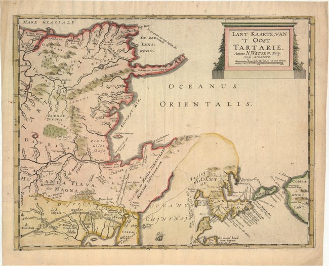
This fascinating map of northeastern Asia by Nicolaas Witsen shows numerous geographical misconceptions. Although Korea is correctly shown as a peninsula, there are conjectural dotted lines connecting it to Eso (Hokkaido). Further to the east is Compagnies Lant, which was supposedly discovered by Jean de Gama. Maarten Gerritsz de Vries described Compagnies Lant and the adjacent Staten Eylant in the diary of his exploration to Hokkaido and the Kuril Islands in 1643. Witsen used De Vries' diary in preparation for his work on Northern Asia, in which this map was published.
A long, slender peninsula protrudes east from northeastern Siberia -- presumably the Kamchatka Peninsula -- with a notation that it consists of "ice and stone cliffs." The Amur River is shown flowing west, rather than south-southwest, with its mouth in the Sea of Okhotsk (Oceanus Orientalis), rather than in the narrow Strait of Tartary, which divides the Russian mainland from the island of Sakahlin. In China, the Great Wall is prominently depicted and several cities are named. In this map, Peking is correctly shown at 40 degrees latitude, which had been measured by the Jesuits.
Nicolaas Witsen (1641-1717) was a Dutchman who was a cartographer, authority on shipbuilding, administrator of the VOC, and served as mayor of Amsterdam multiple times. Witsen traveled to Moscow in 1664-65, keeping a diary and collecting artifacts. He became fascinated about Russia and obtained all information available at the time on the subject, including maps, travelogues, manuscripts and objects. In 1692, Witsen published the most comprehensive and authoritative work on Russia and northern Asia, Noord en Oost Tartarye. A second expanded edition was published in 1705 with additional maps, and again reprinted in 1785. All editions are very rare.
References:
Condition: A
A nice impression with attractive color and a large "Pro Patria" watermark. There are several extraneous creases along the centerfold that have been pressed flat and a few faint spots.